Kangan County
Kangan County (Persian: شهرستان کنگان) is in Bushehr province, Iran. Its capital is the city of Bandar Kangan.
Kangan County
Persian: شهرستان کنگان | |
|---|---|
County | |
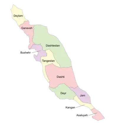 Location of Kangan County in Bushehr province (bottom, yellow) | |
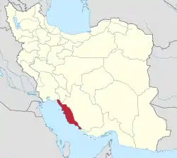 Location of Bushehr province in Iran | |
| Coordinates: 27°42′07″N 52°15′31″E[1] | |
| Country | |
| Province | Bushehr |
| Capital | Bandar Kangan |
| Districts | Central, Siraf |
| Population (2016) | |
| • Total | 107,801 |
| Time zone | UTC+3:30 (IRST) |
| Kangan County can be found at GEOnet Names Server, at this link, by opening the Advanced Search box, entering "9206097" in the "Unique Feature Id" form, and clicking on "Search Database". | |
At the 2006 census, the county's population was 95,113 in 15,220 households.[2] The following census in 2011 counted 170,774 people in 25,667 households.[3] At the 2016 census, the county's population was 107,801 in 27,873 households, by which time Asaluyeh District had been separated from the county to form Asaluyeh County.[4]
Administrative divisions
The population history and structural changes of Kangan County's administrative divisions over three consecutive censuses are shown in the following table. The latest census shows one district, two rural districts, and three cities.[4]
| Administrative Divisions | 2006[2] | 2011[3] | 2016[4] |
|---|---|---|---|
| Central District | 40,793 | 105,190 | 107,801 |
| Howmeh Rural District | 733 | 1,889 | 3,358 |
| Taheri Rural District | 3,886 | 8,320 | 23,138 |
| Tonbak Rural District1 | |||
| Bandar Kangan (city) | 23,921 | 76,329 | 60,187 |
| Bandar Siraf (city) | 3,500 | 7,137 | 6,992 |
| Bank (city) | 8,753 | 11,515 | 14,126 |
| Asaluyeh District2 | 54,320 | 65,584 | |
| Asaluyeh Rural District | 31,319 | 32,977 | |
| Nayband Rural District | 10,437 | 13,220 | |
| Asaluyeh (city) | 4,746 | 7,884 | |
| Nakhl Taqi (city) | 7,818 | 11,503 | |
| Siraf District1 | |||
| Shirinu Rural District1 | |||
| Taheri Rural District | |||
| Bandar Siraf (city) | |||
| Total | 95,113 | 170,774 | 107,801 |
| 1Established in 2017[5] 2Became a part of Asaluyeh County | |||
Wikimedia Commons has media related to Kangan County.
References
- OpenStreetMap contributors (31 March 2023). "Kangan County" (Map). OpenStreetMap. Retrieved 31 March 2023.
- "Census of the Islamic Republic of Iran, 1385 (2006)". AMAR (in Persian). The Statistical Center of Iran. p. 18. Archived from the original (Excel) on 20 September 2011. Retrieved 25 September 2022.
- "Census of the Islamic Republic of Iran, 1390 (2011)" (Excel). Iran Data Portal (in Persian). The Statistical Center of Iran. p. 18. Retrieved 19 December 2022.
- "Census of the Islamic Republic of Iran, 1395 (2016)". AMAR (in Persian). The Statistical Center of Iran. p. 18. Archived from the original (Excel) on 3 August 2017. Retrieved 19 December 2022.
- Jahangiri, Ishaq (22 March 2017). "Approval letter regarding country divisions in Jam, Kangan Counties in Bushehr province". Islamic Parliament Research Center of the Islamic Republic of Iran (in Persian). Council of Ministers, Ministry of Interior. Archived from the original on 13 March 2019. Retrieved 31 March 2023.
| Capital |  | ||||||||||||||||||||
|---|---|---|---|---|---|---|---|---|---|---|---|---|---|---|---|---|---|---|---|---|---|
| Counties and cities |
| ||||||||||||||||||||
| Landmarks |
| ||||||||||||||||||||
| populated places | |||||||||||||||||||||
This article is issued from Wikipedia. The text is licensed under Creative Commons - Attribution - Sharealike. Additional terms may apply for the media files.