Juruá, Amazonas
Juruá is a municipality located in the Brazilian state of Amazonas. Its population was 15,106 (2020)[1] and its area is 19,400 km².[2]
Juruá | |
|---|---|
 Flag | |
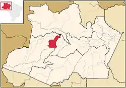 Location of the municipality inside Amazonas | |
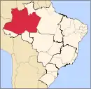
 Juruá Location in Brazil | |
| Coordinates: 3°28′51″S 66°4′8″W | |
| Country | |
| Region | North |
| State | |
| Population (2020) | |
| • Total | 15,106 |
| Time zone | UTC−4 (BRT) |
| • Summer (DST) | UTC−4 (DST no longer used) |
The municipality contains 62% of the 187,982 hectares (464,510 acres) Baixo Juruá Extractive Reserve, created in 2001.[3] The municipality contains about 12% of the Tefé National Forest, created in 1989.[4]
References
- IBGE 2020
- IBGE - "Archived copy". Archived from the original on 2008-06-11. Retrieved 2014-08-03.
{{cite web}}: CS1 maint: archived copy as title (link) - RESEX do Baixo Juruá (in Portuguese), ISA: Instituto Socioambiental, retrieved 2016-10-22
- FLONA de Tefé (in Portuguese), ISA: Instituto Socioambiental, retrieved 2016-10-19
Capital: Manaus | ||||||||||||||
| Mesoregion Centro Amazonense |
|  | ||||||||||||
| Mesoregion Norte Amazonense |
| |||||||||||||
| Mesoregion Sudoeste Amazonense |
| |||||||||||||
| Mesoregion Sul Amazonense |
| |||||||||||||
This article is issued from Wikipedia. The text is licensed under Creative Commons - Attribution - Sharealike. Additional terms may apply for the media files.