Japan National Route 410
National Route 410 (国道410号, Kokudō Yonhyakujūgō) is a national highway located entirely within Chiba Prefecture, Japan. It connects the cities of Tateyama and Kisarazu, spanning the Bōsō Peninsula in a south–north routing. The highway has a total length of 110.4 kilometers (68.6 mi).
 | ||||
|---|---|---|---|---|
| 国道410号 | ||||
National Route 410 highlighted in red | ||||
| Route information | ||||
| Length | 110.4 km[1] (68.6 mi) | |||
| Existed | 1 April 1982–present | |||
| Major junctions | ||||
| South end | ||||
| North end | ||||
| Location | ||||
| Country | Japan | |||
| Highway system | ||||
| ||||
Route description
National Route 410 connects the cities of Tateyama and Kisarazu, spanning Chiba Prefecture's Bōsō Peninsula in a south–north routing. Its southern terminus lies at a junction with National Route 127 and National Route 128 in central Tateyama. It travels south from there towards the southern tip of the Bōsō Peninsula, Cape Nojima. Upon reaching the cape, the highway begins curving to the north heading through Minamibōsō and the former town of Chikura. It has another junction with National Route 128 in the former town of Maruyama, sharing a brief concurrency with the route before continuing north into the city of Kamogawa. The highway has a total length of 110.4 kilometers (68.6 mi).[2][1]
History
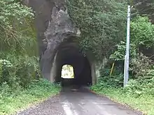
In 1902, the Yomachisaku Daiichi Tunnel (四町作第一隧道, Yomachisaku Daiichi Zuidō) was completed using only hand tools along what would become National Route 410 in the city of Kimitsu. The tunnel is the second oldest tunnel that is designated as a part of a national highway in Japan.[3][4]
National Route 410 was established by the Cabinet of Japan in 1982.[5] Construction began on the Kururi–Makuta Bypass of the narrow sections of the highway including the Yomachisaku Daiichi Tunnel in 1989. The 10.7-kilometer-long (6.6 mi) bypass was scheduled to be completed by 2015,[6] but as of 2021, the bypass has yet to be completed.[2] On 23 December 2015, a 20-meter-long (66 ft) section of the Yomachisaku Daiichi Tunnel's shotcrete lining collapsed following a re-application of the supportive lining a month prior to the collapse. The tunnel lining was repaired by the following day.[7]
Major intersections
The route lies entirely within Chiba Prefecture.
| Location | km[2] | mi | Destinations | Notes | |||
|---|---|---|---|---|---|---|---|
| Tateyama | 0.0 | 0.0 | Southern terminus; highway continues north as National Route 127 | ||||
| 1.3 | 0.81 | Chiba Prefecture Route 188 east – Chikura | |||||
| 1.5 | 0.93 | Chiba Prefecture Route 86 – Shirahama, central Tateyama | |||||
| 2.3 | 1.4 | ||||||
| 9.8 | 6.1 | Chiba Prefecture Route 257 north (Bōsō Flower Line) – Sunozaki | |||||
| 10.0 | 6.2 | Chiba Prefecture Route 252 south – Tomisaki Fishing Port | |||||
| Minamibōsō | 15.9 | 9.9 | Chiba Prefecture Route 86 north – Tateyama, Shirahama | ||||
| 29.1 | 18.1 | ||||||
| 29.2 | 18.1 | Chiba Prefecture Route 251 south – Chikura-Seaside | |||||
| 30.3 | 18.8 | Chiba Prefecture Route 241 west – Chikura Station | |||||
| 32.8 | 20.4 | Chiba Prefecture Route 297 north – Kamogawa, Rosemary Park | |||||
| 35.5 | 22.1 | Southern end of National Route 128 concurrency | |||||
| 36.1 | 22.4 | Northern end of National Route 128 concurrency | |||||
| 38.3 | 23.8 | ||||||
| 41.1 | 25.5 | Chiba Prefecture Route 258 west – Masuma | |||||
| 46.1 | 28.6 | Chiba Prefecture Route 89 west – Iwai | Southern end of Chiba Prefecture Route 89 concurrency | ||||
| 47.8 | 29.7 | Chiba Prefecture Route 89 east – Kamogawa | Northern end of Chiba Prefecture Route 89 concurrency | ||||
| Kamogawa | 53.2 | 33.1 | Chiba Prefecture Route 34 (Nagasa Kaidō) – Hota, central Kamogawa | ||||
| Kimitsu | 65.4 | 40.6 | Southern end of National Route 465 concurrency | ||||
| 74.0 | 46.0 | Northern end of National Route 465 concurrency, southern end of Chiba Prefecture Route 24 concurrency | |||||
| 81.8 | 50.8 | Chiba Prefecture Route 32 east – Ōtaki Chiba Prefecture Route 93 west – Futtsu | |||||
| 82.2 | 51.1 | Chiba Prefecture Route 145 north – Kisarazu | |||||
| 84.1 | 52.3 | Large trucks are prohibited from going south on the Kururi–Makuta Bypass | |||||
| 84.5 | 52.5 | Chiba Prefecture Route 163 west – Kisarazu | |||||
| 86.3 | 53.6 | Chiba Prefecture Route 23 west – Kisarazu, Kazusa Akademia Park, Obitsu Station | |||||
| 86.5 | 53.7 | Chiba Prefecture Route 160 east – Itabu, Kururi Castle | Southern end of Chiba Prefecture Route 160 concurrency | ||||
| 87.1 | 54.1 | Chiba Prefecture Route 160 ends | Northern end of Chiba Prefecture Route 160 concurrency | ||||
| Kisarazu | 90.0 | 55.9 | Chiba Prefecture Route 166 – Shimogōri, Makuta | ||||
| 90.6 | 56.3 | Kisarazu-higashi Interchange (C4 exit 105) | |||||
| 92.3 | 57.4 | One-quadrant interchange | |||||
| Sodegaura | 93.7 | 58.2 | Northern end of Chiba Prefecture Route 24 concurrency, southern end of National Route 409 concurrency | ||||
| 95.8 | 59.5 | Chiba Prefecture Route 165 east – Ichihara, Katsuura Chiba Prefecture Route 167 south – Kururi | Southern end of Chiba Prefecture Route 165 concurrency | ||||
| 96.9 | 60.2 | Chiba Prefecture Route 145 south – Kimitsu, Kazusa Akademia Park | Southern end of Chiba Prefecture Route 145 concurrency | ||||
| 97.2 | 60.4 | Chiba Prefecture Route 145 north – Nagaura | Northern end of Chiba Prefecture Route 145 concurrency | ||||
| 97.4 | 60.5 | Chiba Prefecture Route 165 west – Yokota Station | Northern end of Chiba Prefecture Route 165 concurrency | ||||
| 99.2 | 61.6 | Chiba Prefecture Route 33 south – Kimitsu, Kazusa Akademia Park | |||||
| Kisarazu | 99.6 | 61.9 | Kisarazu-kita Interchange (E14 exit 15) | ||||
| 99.2 | 61.6 | Chiba Prefecture Route 33 south – Kimitsu, Kazusa Akademia Park | |||||
| 102.7 | 63.8 | Partial interchange; northbound entrance, southbound exit | |||||
| 103.2 | 64.1 | Chiba Prefecture Route 146 – Central Kisarazu, Sodegaura | |||||
| Sodegaura | 105.0 | 65.2 | Sodegaura Interchange (CA exit 3); northbound entrance, southbound exit | ||||
| 105.2 | 65.4 | National Route 410 reverses here | |||||
| 105.4 | 65.5 | Sodegaura Interchange (CA exit 3); northbound entrance, southbound exit | |||||
| Kisarazu | 107.2 | 66.6 | Chiba Prefecture Route 146 – Central Kisarazu, Sodegaura | ||||
| 108.0 | 67.1 | Partial interchange; northbound entrance, southbound exit, northern end of National Route 409 concurrency | |||||
| 108.6 | 67.5 | Chiba Prefecture Route 146 north – Sodegaura | |||||
| 110.4 | 68.6 | Chiba Prefecture Route 90 west (Bōsō Ōdan-dōro) – Kisarazu Port, central Kisarazu | Northern terminus; interchange; highway continues west as Chiba Prefecture Route 90 | ||||
1.000 mi = 1.609 km; 1.000 km = 0.621 mi
| |||||||
See also
References
- "一般国道の路線別、都道府県別道路現況" [Road statistics by General National Highway route and prefecture] (PDF) (in Japanese). Ministry of Land, Infrastructure, Transport and Tourism. Retrieved 12 February 2020.
- Google (19 April 2021). "Route 410" (Map). Google Maps. Google. Retrieved 19 April 2021.
- "ビックリ道路大集合…!これが「酷道・怖道・険道」だ" [Several surprising roads. Cool, scary, and steep roads] (in Japanese). Kodansha. 4 February 2021. Retrieved 19 April 2021.
- Nogishi, Yasuyuki (12 April 2021). "房総半島は素掘りトンネル王国!? 日本で2番目に古い国道トンネルを走ってみた". Bike News (in Japanese). MediaVague. Retrieved 19 April 2021.
- "一般国道の路線を指定する政令" [Cabinet Order Designating General National Routes]. Act of 1965 (in Japanese). Cabinet of Japan. Retrieved 19 April 2021 – via Wikisource.
- "国道410号 久留里馬来田バイパス" [National Route 410 Kururi–Makuta Bypass] (PDF) (in Japanese). Chiba Prefecture. 2005. Retrieved 21 April 2021.
- "23-ton collapse blocks Chiba tunnel; no one injured". The Japan Times. 24 December 2015. Retrieved 19 April 2021.
External links
 Media related to Category:Route 410 (Japan) at Wikimedia Commons