Irepodun/Ifelodun
Irepodun/Ifelodun is a Local Government Area of Ekiti State, Nigeria. Irepodun/Ifelodun is predominantly a homogeneous society and carefully populated by Yoruba speaking people of the South West of Nigeria. It has an area of 356 km2 and a population of 129,149 at the 2006 census. The major religions of the people are Christianity and Islam while a percentage of the people are traditional religion worshippers.[1]
Irepodun/Ifelodun | |
|---|---|
| Country | |
| State | Ekiti State |
| Government | |
| • Local Government Chairman and the Head of the Local Government Council | Pastor Olowoyo Sunday |
| • Local Government Secretary | Adebola Adeyeye |
| Time zone | UTC+1 (WAT) |
The thriving industries in the local government include timber and saw mills which include Mighty Sawmill at Igede-Ekiti, Ilamoye Sawmill at Igede-Ekiti, Olorunde Sawmill at Iyin-Ekiti, Igbemo Rice at Igbemo Ekit, ROMACO Company at Igbemo Ekit, Okeorun Sawmill at Orun-Ekiti, Osalade Sawmil at Orun-Ekiti, Oke Uba Sawmill at Awo-Ekiti and Iyedi Sawmill at Igbemo-Ekiti; photo studios; and Hotels, some of which include Corner Stone Hotel, God's Health Hotel, Liberty Hotel and many more.[1]
The places in the Irepodun Local Government that attract tourists from all over are the Osun Tourist Center and Elemi Tourist Center, both located at Igede-Ekiti.
The postal code of the area is 362.[2]
Geography
The Irepodun/Ifelodun LGA covers an area of 356 km2 and experiences average temperatures of 27 °C. Esu Hills are one of the numerous hills in the region. The Osun, Orunro, and Elemi rivers are among the many rivers and tributaries that flow through the Irepodun/Ifelodun LGA, where the average humidity is 69 percent.The Irepodun/Ifelodun LGA covers an area of 356 km2 and experiences average temperatures of 27 °C. Esu Hills are one of the numerous hills in the region. The Osun, Orunro, and Elemi rivers are among the many rivers and tributaries that flow through the Irepodun/Ifelodun LGA, where the average humidity is 69 percent.[3]
Irepodun/Ifelodun LGA was created on the 11th day of June 1989 from Ekiti central LGA.[3]
Towns & Villages
The major towns in Irepodun/Ifelodun are:[4]
- Igede-Ekiti
- Iyin-Ekiti
- Orun-Ekiti
- Awo-Ekiti
- Iropora-Ekiti
- Eyio-Ekiti
- Esure-Ekiti
- Iworoko-Ekiti
- Are-Ekiti
- Afao-Ekiti
- Araromi Obo-Ekiti
- Igbemo-Ekiti
- Ikogosi-Ekiti
- Aramoko-Ekiti
- Erijiyan Ekiti
Irepodun/Ifelodun also comprises villages and farmsteads which include:
- Odo Uro
- Ejiko
- Okoro
- Amadin
- Itaasae
- Aba Olorunda
- Aroto
- Tungba
- Ita Ake
- Olusegun Camp
- Oriokuta Camp
- Aba Osun
- Asa Oloro
- Abuja Camp
- Surulere
- Oriokuta Camp
- Kajola Camp
- Ajebamidele I
- Araromi Oke Aro
- Ajayi Oke
- Ajayi Odo
- Temidire Camp
- Orisumibare Camp
- Ajebamidele II
- Kosubu Town
- Ita Oko Aba Camp
- Igbo Eku Camp
Gallery
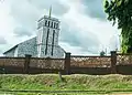 Anglican church, Igede-Ekiti
References
- Nigeria, Media (2022-04-15). "History Of Irepodun/Ifelodun LGA, Ekiti State". Media Nigeria. Retrieved 2023-08-20.
- "Post Offices- with map of LGA". NIPOST. Archived from the original on 2009-10-07. Retrieved 2009-10-20.
- "Irepodun / Ifelodun Local Government Area". www.manpower.com.ng. Retrieved 2023-08-20.
- "Irepodun/Ifelodun Local Government Area". www.finelib.com. Retrieved 2023-08-20.
State capital: Ado Ekiti | ||
| Local Government Areas | 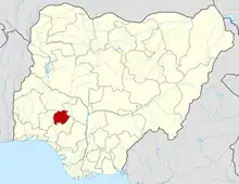 | |