IJzerlo
IJzerlo is a hamlet in the municipality of Aalten, between Aalten and Dinxperlo in the (Achterhoek region) in the eastern Netherlands.
IJzerlo | |
|---|---|
 Skyline of IJzerlo | |
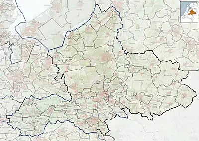 IJzerlo Location in the province of Gelderland  IJzerlo IJzerlo (Netherlands) | |
| Coordinates: 51°53′N 6°32′E | |
| Country | Netherlands |
| Province | Gelderland |
| Municipality | Aalten |
| Area | |
| • Total | 0.11 km2 (0.04 sq mi) |
| Elevation | 24 m (79 ft) |
| Population (2021)[1] | |
| • Total | 165 |
| • Density | 1,500/km2 (3,900/sq mi) |
| Time zone | UTC+1 (CET) |
| • Summer (DST) | UTC+2 (CEST) |
| Postal code | 7122 |
| Dialing code | 0543 |
It was first mentioned in 1356 as Yserlo, and means "forest with primeval soil".[3] In 1840, it was home to 438 people.[4] The postal authorities have placed it under Aalten.[5]
IJzerlo has built a local reputation for its annual Farm & Country Fair,[4] the Easter fire and the provision of outdoor play.

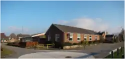
Former school
References
- "Kerncijfers wijken en buurten 2021". Central Bureau of Statistics. Retrieved 18 March 2022.
- "Postcodetool for 7122AA". Actueel Hoogtebestand Nederland (in Dutch). Het Waterschapshuis. Retrieved 18 March 2022.
- "IJzerlo - (geografische naam)". Etymologiebank (in Dutch). Retrieved 18 March 2022.
- "IJzerlo". Plaatsengids (in Dutch). Retrieved 18 March 2022.
- "Postcode 7122 in Aalten". Postcode bij adres (in Dutch). Retrieved 18 March 2022.
Wikimedia Commons has media related to IJzerlo.
This article is issued from Wikipedia. The text is licensed under Creative Commons - Attribution - Sharealike. Additional terms may apply for the media files.