Hurricane Dora (2023)
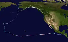
Hurricane Dora, also known as Typhoon Dora, was a long‑lived and powerful tropical cyclone that tracked across all three North Pacific basins in August 2023. The fourth named storm, fourth hurricane, and second major hurricane[lower-alpha 1] of the 2023 Pacific hurricane season, Dora developed on July 31, from a tropical wave that had crossed over Central America from the North Atlantic, and became a tropical storm early the following day. Then during August 2–3, the system rapidly intensified to Category 4 strength. Dora moved generally westward while a Pacific hurricane, and crossed the International Date Line on August 11, at which time it was reclassified as a typhoon. The sixth typhoon of the 2023 Pacific typhoon season, the system gradually deteriorated over the open ocean, and degenerated into a remnant low on August 15.
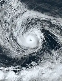
 Dora at peak intensity on August 8, 2023 | |
| Meteorological history | |
|---|---|
| Formed | July 31, 2023 |
| Dissipated | August 21, 2023 |
| Category 4 hurricane | |
| 1-minute sustained (SSHWS/NWS) | |
| Highest winds | 145 mph (230 km/h) |
| Lowest pressure | 942 mbar (hPa); 27.82 inHg |
| Typhoon | |
| 10-minute sustained (JMA) | |
| Highest winds | 150 km/h (90 mph) |
| Lowest pressure | 975 hPa (mbar); 28.79 inHg |
| Overall effects | |
| Fatalities | None |
| Damage | None |
| Areas affected | Hawaii, Johnston Atoll, Alaska, Wake Island |
| IBTrACS | |
Part of the 2023 Pacific hurricane season and the 2023 Pacific typhoon season | |
Dora never posed a direct threat to any land mass. However, the storm's high winds while south of Hawaii, together with an anticyclone to the north of Hawaii, did produce strong gradient winds over the islands, which in turn helped cause the 2023 Hawaii wildfires. Philippe Papin, a hurricane specialist with the National Hurricane Center, argued that Hurricane Dora played only a minor role in "enhancing low-level flow over Maui at fire initiation time."
Meteorological origins

Tropical storm (39–73 mph, 63–118 km/h)
Category 1 (74–95 mph, 119–153 km/h)
Category 2 (96–110 mph, 154–177 km/h)
Category 3 (111–129 mph, 178–208 km/h)
Category 4 (130–156 mph, 209–251 km/h)
Category 5 (≥157 mph, ≥252 km/h)
Unknown
A tropical wave which the National Hurricane Center (NHC) had been monitoring since July 16 crossed over Central America into the Eastern Pacific on July 29, off the coast of El Salvador, producing a large area of rain and thunderstorms amid a favorable environment.[2] The system became better organized on July 31, and Tropical Depression Five‑E developed that afternoon.[3] Deep convection increased within the depression, and it strengthened into Tropical Storm Dora early the following day.[4]
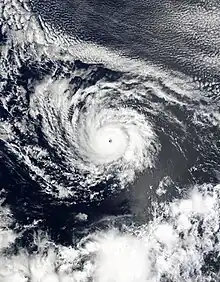
During August 2–3, Dora rapidly intensified to Category 4 strength, far to the southwest of Cabo San Lucas, Baja California Sur. Then, after undergoing an eyewall replacement cycle,[5] and weakening to a Category 3, it re-intensified to Category 4, with sustained winds reaching 140 mph (220 km/h) early on August 4. Later that day and into the next, the system weakened to Category 2, with winds dropping to 105 mph (165 km/h), before rebounding. Dora reached Category 4 for a third time on August 5, with sustained winds of 145 mph (230 km/h).[6] displaying a symmetric 17-mile-wide (28 km) eye, surrounded by a thick ring of intense thunderstorm activity, wrapped within bands of showers and thunderstorms revolving around its core.[7] At 15:00 UTC the next day, Dora, experiencing a slight fluctuation in intensity while moving toward the west at 21 mph (33 km/h), crossed over into the Central Pacific basin.[8]
Intensification, peak intensity, and wildfires in Hawaii


Dora remained a powerful Category 4 hurricane on August 8, as it passed far to the south of the Island of Hawaiʻi with sustained winds of 130 mph (215 km/h).[9][10] Later, on the morning of August 9, Dora strengthened once again, generating winds of 145 mph (230 km/h) amid a low-shear, warm sea surface temperatures environment. It continued to display annular characteristics, with a well-defined, symmetrical 9.2-mile-wide (15 km) eye, surrounded by a compact central dense overcast of less than 120 miles (190 km) wide.[11] Late that same day, Dora's annular structure deteriorated, leaving the system susceptible to dry air intrusions.[12] During this time, the hurricane passed south of Johnston Island.[13] As a result of the change in storm structure, Dora weakened to Category 3 strength on the morning of August 10.[12] As the day progressed, southerly shear caused the hurricane's structure to begin to degrade some as it shifted its course toward the west-northwest along the southwest edge of a high pressure system.[14] At 21:00 UTC on August 11, Dora weakened to Category 2 strength about 900 mi (1,450 km) south of Midway Island.[15] The same day, Dora moved into the basin from the Central Pacific basin.[16]
Though Dora did not pose a direct threat to the Hawaiian Islands, the National Weather Service in Honolulu did issue numerous weather warnings and advisories, especially red flag warnings, for portions of the various islands in expectation of the hurricane helping enhance trade winds in conjunction with an ongoing drought.[17] A steep pressure gradient between a strong anticyclone to the north of Hawaii and Dora to the south produced incredibly strong gradient winds over the islands which in turn helped cause multiple wildfires in Hawaii. The most devastating fire broke out on Maui, where at least 98 people were killed.[18] In addition, more than 2,200 buildings, primarily in Lahaina, were damaged or destroyed. The wildfires became the deadliest natural disaster in recorded Hawaii history.[19][20] The exact significance of Hurricane Dora and how it impacted the fires themselves remains somewhat unclear. Meteorologists noted that the storm's center remained more than 700 miles (1,100 km) from the islands and that it remained relatively small in size; however it also remained "remarkably potent for a long time", logging more hours as a Category 4 hurricane than any other storm in the Pacific for over 50 years.[21] Philippe Papin, a hurricane specialist with the National Hurricane Center, argued that Hurricane Dora played only a minor role in "enhancing low-level flow over Maui at fire initiation time."[22]
Transition into a typhoon, weakening and demise
At 00:00 UTC, August 12, the JMA and the JTWC initiated advisories on Dora, declaring that it had just crossed the International Date Line and classifying it as Typhoon Dora.[23] The cloud tops further warmed and its eye vanished from satellite imagery.[24] Dora showed significant deterioration along the system's northern flank.[25] Dora became increasingly sheared by early August 13, interacting with an upper-level trough.[26] Vertical wind shear exceeded 35 km/h (25 mph). Further decay in the organization of the storm's deep convection caused Dora to be downgraded to a tropical storm.[27] With Dora's ragged center, the system remained disorganized, as wind shear was becoming displaced to the east.[28][29] By the early hours of August 15, both agencies issued their final warnings on Dora; its LLCC further became broad and exposed.[30][31] The JMA, however, continued to monitor the system until it was last noted on 18:00 UTC of August 21.
See also
- Weather of 2023
- Tropical cyclones in 2023
- List of Category 4 Pacific hurricanes
- Hurricane Fico (1978)
- Hurricane Tina (1992)
- Hurricane John (1994) – the second longest-lived and furthest-travelling tropical cyclone ever recorded.
- Hurricane Dora (1999) – A hurricane with the same name that also crossed the International Dateline
- Hurricane Genevieve (2014)
- Hurricane Hector (2018)
Notes
- A major hurricane is a storm that ranks as Category 3 or higher on the Saffir–Simpson hurricane wind scale.[1]
References
- Saffir–Simpson Hurricane Wind Scale. National Hurricane Center (Report). National Oceanic and Atmospheric Administration. May 23, 2013. Retrieved May 6, 2019.
- Bucci, Lisa (July 29, 2023). Tropical Weather Outlook (Report). Miami, Florida: National Hurricane Center. Retrieved July 30, 2023.
- Papin, Philippe (July 31, 2023). Tropical Depression Five-E Discussion Number 1 (Report). Miami, Florida: National Hurricane Center. Retrieved July 31, 2023.
- Pasch, Richard (August 1, 2023). Tropical Storm Dora Discussion Number 3 (Report). Miami, Florida: National Hurricane Center. Retrieved August 1, 2023.
- Beven, Jack (August 3, 2023). Hurricane Dora Discussion Number 13 (Report). Miami, Florida: National Hurricane Center. Retrieved August 8, 2023.
- Berg, Robbie (August 5, 2023). Hurricane Dora Discussion Number 23 (Report). Miami, Florida: National Hurricane Center. Retrieved August 7, 2023.
- Hobgood, Jay (August 5, 2023). "Hurricane Dora Strengthens Back to Cat. 4". weatherusa.net. Columbus, Ohio. Retrieved August 8, 2023.
- Barker, Aaron; Oberholtz, Chris; Yablonski, Steven; Brinkmann, Heather (August 6, 2023). "Hurricane Dora climbs back to Category 4 as it spins south of Hawaii in central Pacific". FOX Weather. Retrieved August 6, 2023.
- Jelsema, Jon (August 8, 2023). Hurricane Dora Discussion Number 33 (Report). Honolulu, Hawaii: Central Pacific Hurricane Center. Retrieved August 8, 2023.
- "Dora remains Category 4 hurricane as passes south of Hawaiʻi Island, bringing high winds, surf, fire hazards". Big Island Now. August 8, 2023. Retrieved August 8, 2023.
- Powell, Jeff (August 9, 2023). Hurricane Dora Discussion Number 39 (Report). Honolulu, Hawaii: Central Pacific Hurricane Center. Retrieved August 10, 2023.
- Foster, Matthew; Birchard, Tom (August 10, 2023). Hurricane Dora Advisory Number 41 (Report). Honolulu, Hawaii: Central Pacific Hurricane Center. Retrieved August 10, 2023.
- Hobgood, Jay (August 10, 2023). "Hurricane Dora Passes South of Johnston Island". weatherusa.net. Columbus, Ohio. Retrieved August 10, 2023.
- Foster, Matthew; Birchard, Tom (August 11, 2023). Hurricane Dora Discussion Number 45 (Report). Honolulu, Hawaii: Central Pacific Hurricane Center. Retrieved August 11, 2023.
- Kodema, Kevin (August 11, 2023). Hurricane Dora Advisory Number 46 (Report). Honolulu, Hawaii: Central Pacific Hurricane Center. Retrieved August 11, 2023.
- Kodema, Kevin (August 11, 2023). Hurricane Dora Advisory Number 46 (Report). Honolulu, Hawaii: Central Pacific Hurricane Center. Retrieved August 11, 2023.
- "Hurricane Dora passing south of Hawaii". Honolulu Star-Advertiser. August 8, 2023. Retrieved August 8, 2023.
- "Maui police raise county's official wildfire death toll to 98". Honolulu Star-Advertiser. October 3, 2023. Retrieved October 4, 2023.
- Sangal, Aditi; Levenson, Eric; Vogt, Adrienne (August 9, 2023). "Wildfires burning across Maui prompt evacuations". CNN. Retrieved August 9, 2023.
- Pequeño IV, Antonio (August 12, 2023). "Hawaii Wildfires: 80 Confirmed Dead In State's Deadliest Natural Disaster In History". Forbes. Retrieved August 13, 2023.
- Henson, Bob; Masters, Jeff (August 10, 2023). "What caused the deadly Hawai'i wildfires? » Yale Climate Connections". Yale Climate Connections. Archived from the original on August 12, 2023. Retrieved August 13, 2023.
- @pppapin (August 10, 2023). "Plenty of media talking #Hurricane #Dora influence on #MauiFires, so worth a deep dive quantifying overall TC impact by removing vortex. Result Dora played a *very* minor role, slightly enhancing low-level flow over Maui at fire initiation time" (Tweet). Retrieved August 15, 2023 – via Twitter.
- "Tropical Cyclone Information: T2308 (DORA)". Japan Meteorological Agency. Archived from the original on 2023-08-12. Retrieved 2023-08-12.
- Prognostic Reasoning for Typhoon 05E (Dora) Warning No. 47 (Report). United States Joint Typhoon Warning Center. 12 August 2023. Archived from the original on 2023-08-12. Retrieved 12 August 2023.
- Prognostic Reasoning for Typhoon 05E (Dora) Warning No. 48 (Report). United States Joint Typhoon Warning Center. 12 August 2023. Archived from the original on 2023-08-12. Retrieved 12 August 2023.
- Prognostic Reasoning for Typhoon 05E (Dora) Warning No. 50 (Report). United States Joint Typhoon Warning Center. 13 August 2023. Archived from the original on 2023-08-13. Retrieved 13 August 2023.
- Prognostic Reasoning for Tropical Storm 05E (Dora) Warning No. 51 (Report). United States Joint Typhoon Warning Center. 13 August 2023. Archived from the original on 2023-08-13. Retrieved 13 August 2023.
- Prognostic Reasoning for Tropical Storm 05E (Dora) Warning No. 53 (Report). United States Joint Typhoon Warning Center. 13 August 2023. Archived from the original on 2023-08-13. Retrieved 13 August 2023.
- Prognostic Reasoning for Tropical Storm 05E (Dora) Warning No. 58 (Report). United States Joint Typhoon Warning Center. 14 August 2023. Archived from the original on 2023-08-15. Retrieved 14 August 2023.
- "WTPQ51 RJTD 150600". Japan Meteorological Agency. Archived from the original on 2023-08-15. Retrieved 2023-08-15.
- Prognostic Reasoning for Tropical Depression 05E (Dora) Warning No. 63 (Report). United States Joint Typhoon Warning Center. 15 August 2023. Archived from the original on 2023-08-16. Retrieved 15 August 2023.
