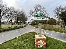
Holme Hale
Holme Hale is a village situated in the Breckland District of Norfolk and covers an area of 1069 hectares (4.13 square miles) with an estimated population of 444 as of UK census 2001.[1] The village lies 1+1⁄2 miles (2.4 km) south of Necton and 5+1⁄2 miles (8.9 km) by road east from Swaffham.
| Holme Hale | |
|---|---|
 Church Of St. Andrew, Holme Hale | |
 Holme Hale Location within Norfolk | |
| Area | 10.69 km2 (4.13 sq mi) |
| Population | 444 UK census 2001 |
| • Density | 42/km2 (110/sq mi) |
| OS grid reference | TF88420724 |
| District | |
| Shire county | |
| Region | |
| Country | England |
| Sovereign state | United Kingdom |
| Post town | THETFORD |
| Postcode district | IP25 |
| Dialling code | 01760 |
| Police | Norfolk |
| Fire | Norfolk |
| Ambulance | East of England |
| UK Parliament | |
Holme Hale is served by St Andrews church[2] in the Benefice of Necton.[3]
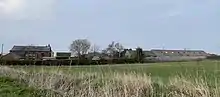
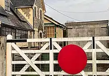
It once had a railway station on the line between Swaffham and Thetford. The station and goods sheds are now private dwellings and form part of the satellite hamlet of Holme Hale Station Road.
Holme Hale Hall opens its gardens for the charitable NGS.[4]
Holme Hale hosts an ADSL broadband enabled telephone exchange serving approx. 1,464 residential premises and 59 non-residential premises.[5]
References
- Census population and household counts for unparished urban areas and all parishes. Office for National Statistics & Norfolk County Council (2001). Retrieved 20 June 2009.
- Norfolk churches
- Necton Benefice
- NGS
- ADSL stats