Hermeville
Hermeville is a commune in the Seine-Maritime department in the Normandy region in northern France.
Hermeville | |
|---|---|
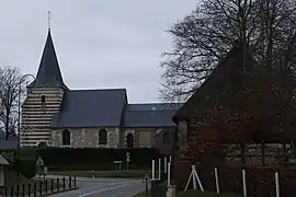 The church in Hermeville | |
 Coat of arms | |
Location of Hermeville | |
 Hermeville  Hermeville | |
| Coordinates: 49°35′52″N 0°15′52″E | |
| Country | France |
| Region | Normandy |
| Department | Seine-Maritime |
| Arrondissement | Le Havre |
| Canton | Octeville-sur-Mer |
| Intercommunality | Le Havre Seine Métropole |
| Government | |
| • Mayor (2020–2026) | Daniel Lemesle[1] |
| Area 1 | 3.81 km2 (1.47 sq mi) |
| Population | 354 |
| • Density | 93/km2 (240/sq mi) |
| Time zone | UTC+01:00 (CET) |
| • Summer (DST) | UTC+02:00 (CEST) |
| INSEE/Postal code | 76357 /76280 |
| Elevation | 80–124 m (262–407 ft) (avg. 15 m or 49 ft) |
| 1 French Land Register data, which excludes lakes, ponds, glaciers > 1 km2 (0.386 sq mi or 247 acres) and river estuaries. | |
Geography
A small farming village situated in the Pays de Caux, some 9 miles (14 km) northeast of Le Havre, at the junction of the D925 and D125 roads.
Heraldry
Arms of Hermeville |
The arms of Hermeville are blazoned : Quarterly 1: gules, a dove (descending?) Or; 2: Azure, a dove rising contourny argent; 3: Azure, a sword fesswise argent, garnished Or, and in chief a helm argent; and 4: Gules, a garb Or, tied sable.
|
Population
| Year | Pop. | ±% p.a. |
|---|---|---|
| 1968 | 126 | — |
| 1975 | 239 | +9.58% |
| 1982 | 342 | +5.25% |
| 1990 | 357 | +0.54% |
| 1999 | 372 | +0.46% |
| 2007 | 359 | −0.44% |
| 2012 | 370 | +0.61% |
| 2017 | 366 | −0.22% |
| Source: INSEE[3] | ||
Places of interest
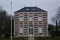 The town hall.
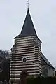 Saint Pierre Church.

- The chapel of St.Pierre, dating from the seventeenth century.
- The sixteenth-century stone cross in the cemetery.
References
- Liste des maires du département de la Seine-Maritime, 10 August 2020
- "Populations légales 2020". The National Institute of Statistics and Economic Studies. 29 December 2022.
- Population en historique depuis 1968, INSEE
External links
Wikimedia Commons has media related to Hermeville.
- Hermeville on the Quid website (in French)
This article is issued from Wikipedia. The text is licensed under Creative Commons - Attribution - Sharealike. Additional terms may apply for the media files.