Harem District
Harem District (Arabic: منطقة حارم, romanized: manṭiqat Ḥārim) is a district of the Idlib Governorate in northwestern Syria. The administrative centre is the city of Harem. At the 2004 census, it had a population of 175,482.[2] Name is identical with haram meaning forbidden in Islam.
Harem District
منطقة حارم | |
|---|---|
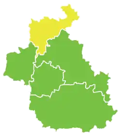
 Map of Harem District within Idlib Governorate | |
| Coordinates (Harem): 36°12′28″N 36°31′09″E | |
| Country | |
| Governorate | Idlib |
| Seat | Harem |
| Subdistricts | 6 nawāḥī |
| Area | |
| • Total | 736.48 km2 (284.36 sq mi) |
| Population (2004)[1] | |
| • Total | 175,482 |
| • Density | 240/km2 (620/sq mi) |
| Geocode | SY0703 |
Sub-districts
The district of Harem is divided into six sub-districts or nawāḥī (population as of 2004[1]):
- Harem Subdistrict (ناحية حارم): population 12,894.[3]
- Al-Dana Subdistrict (ناحية الدانا): population 60,058.[4]
- Salqin Subdistrict (ناحية سلقين): population 47,939.[5]
- Kafr Takharim Subdistrict (ناحية كفر تخاريم): population 14,772.[6]
- Qurqania Subdistrict (ناحية قورقينا): population 12,552.[7]
- Armanaz Subdistrict (ناحية أرمناز): population 27,267.[8]
References
- "2004 Census Data". UN OCHA. Retrieved 15 October 2015.
- 2004 official census Archived 2013-03-10 at the Wayback Machine
- "Harem nahiyah population". Cbssyr.org. Archived from the original on 2013-02-06. Retrieved 2012-06-20.
- "Ad-Dana Shaykhun nahiyah population". Cbssyr.org. Archived from the original on 2012-12-20. Retrieved 2012-06-20.
- "Salqin nahiyah population". Cbssyr.org. Archived from the original on 2012-12-20. Retrieved 2012-06-20.
- "Kafr Takharim nahiyah population". Cbssyr.org. Archived from the original on 2013-03-13. Retrieved 2012-06-20.
- "Qurqina nahiyah population". Cbssyr.org. Archived from the original on 2013-02-06. Retrieved 2012-06-20.
- "Armanaz nahiyah population". Cbssyr.org. Archived from the original on 2013-02-06. Retrieved 2012-06-20.
This article is issued from Wikipedia. The text is licensed under Creative Commons - Attribution - Sharealike. Additional terms may apply for the media files.