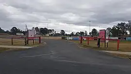
Glenlogan, Queensland
Glenlogan is a rural locality in the City of Logan, Queensland, Australia.[3] It is part of the suburban development corridor south of Brisbane in the Greater Flagstone development area.
| Glenlogan Logan City, Queensland | |||||||||||||||
|---|---|---|---|---|---|---|---|---|---|---|---|---|---|---|---|
 Glenlogan Park, 2023 | |||||||||||||||
 Glenlogan | |||||||||||||||
| Coordinates | 27.8341°S 153.0025°E | ||||||||||||||
| Population | 1,122 (SAL 2021)[1] | ||||||||||||||
| Established | 2017 | ||||||||||||||
| Postcode(s) | 4280[2] | ||||||||||||||
| Area | 6.7 km2 (2.6 sq mi) | ||||||||||||||
| Time zone | AEST (UTC+10:00) | ||||||||||||||
| LGA(s) | Logan City | ||||||||||||||
| State electorate(s) | Jordan | ||||||||||||||
| Federal division(s) | Wright | ||||||||||||||
| |||||||||||||||
History
Glenlogan is situated in the Bundjalung traditional Indigenous Australian country.[4] [5]
The locality takes its name from the former Glenlogan Park thoroughbred stud farm on Lance Road.[3] Glenlogan was designated a locality within the Logan City by the Department of Natural Resources and Mines in September 2017.[6] It was excised from land formerly in Jimboomba.[3]
Geography
The Logan River forms the western and north-western boundaries. The Sydney–Brisbane rail corridor follows the south-eastern boundary.[7]
Road infrastructure
Mount Lindesay Highway passes to the east.
Education
There are no schools in Glenlogan. The nearest primary schools are in neighbouring Jimboomba, Flagstone and Woodhill. The nearest secondary school is in Flagstone.[8]
References
- Australian Bureau of Statistics (28 June 2022). "Glenlogan (Suburb and Locality)". Australian Census 2021 QuickStats. Retrieved 28 June 2022.
- "Glenlogan Postcode". Retrieved 16 November 2019.
- "Glenlogan – locality in City of Logan (entry 50116)". Queensland Place Names. Queensland Government. Retrieved 16 November 2019.
- "Bundjalung – Muurrbay Aboriginal Language and Culture Co-operative". muurrbay.org.au. Retrieved 19 December 2020.
- "AIATSIS code E66: Yugarabul". Federal government. Australian Institute of Aboriginal and Torres Strait Islander Studies. Retrieved 31 July 2020.
- "Glenlogan". Logan City Council. Retrieved 16 November 2019.
- Google (15 September 2021). "Glenlogan, Queensland" (Map). Google Maps. Google. Retrieved 15 September 2021.
- "Queensland Globe". State of Queensland. Retrieved 14 November 2019.