Evergreen Branch
The Evergreen Branch was a branch of the Long Island Rail Road (LIRR) that ran in Brooklyn and part of Queens in New York City. The line, at its fullest extent, ran between Greenpoint, Brooklyn and Ridgewood, Queens. The line consisted of two leased portions. The first portion, between Greenpoint and Jefferson Street, was leased from the Glendale and East River Railroad. The second portion, from Jefferson Street to Ridgewood, was leased from the Brooklyn and Rockaway Beach Railroad Company, and was known as the Evergreen Branch, a name later extended to the rest of the line.
| Evergreen Branch | |||||||||||||||||||||||||||||||||||||||||||||||||||||||||||||||||||||||||||||||||||||||||||||||||
|---|---|---|---|---|---|---|---|---|---|---|---|---|---|---|---|---|---|---|---|---|---|---|---|---|---|---|---|---|---|---|---|---|---|---|---|---|---|---|---|---|---|---|---|---|---|---|---|---|---|---|---|---|---|---|---|---|---|---|---|---|---|---|---|---|---|---|---|---|---|---|---|---|---|---|---|---|---|---|---|---|---|---|---|---|---|---|---|---|---|---|---|---|---|---|---|---|---|
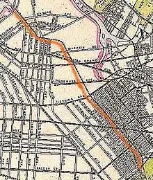
Maximum extent of the Evergreen Branch (1878-1883) | |||||||||||||||||||||||||||||||||||||||||||||||||||||||||||||||||||||||||||||||||||||||||||||||||
| Overview | |||||||||||||||||||||||||||||||||||||||||||||||||||||||||||||||||||||||||||||||||||||||||||||||||
| Status | Abandoned | ||||||||||||||||||||||||||||||||||||||||||||||||||||||||||||||||||||||||||||||||||||||||||||||||
| Owner | Long Island Rail Road | ||||||||||||||||||||||||||||||||||||||||||||||||||||||||||||||||||||||||||||||||||||||||||||||||
| Locale | Brooklyn, New York, USA | ||||||||||||||||||||||||||||||||||||||||||||||||||||||||||||||||||||||||||||||||||||||||||||||||
| Termini |
| ||||||||||||||||||||||||||||||||||||||||||||||||||||||||||||||||||||||||||||||||||||||||||||||||
| Stations | 8 | ||||||||||||||||||||||||||||||||||||||||||||||||||||||||||||||||||||||||||||||||||||||||||||||||
| Service | |||||||||||||||||||||||||||||||||||||||||||||||||||||||||||||||||||||||||||||||||||||||||||||||||
| System | Long Island Rail Road | ||||||||||||||||||||||||||||||||||||||||||||||||||||||||||||||||||||||||||||||||||||||||||||||||
| Operator(s) | Long Island Rail Road | ||||||||||||||||||||||||||||||||||||||||||||||||||||||||||||||||||||||||||||||||||||||||||||||||
| History | |||||||||||||||||||||||||||||||||||||||||||||||||||||||||||||||||||||||||||||||||||||||||||||||||
| Opened | 1874 | ||||||||||||||||||||||||||||||||||||||||||||||||||||||||||||||||||||||||||||||||||||||||||||||||
| Closed | 1984 | ||||||||||||||||||||||||||||||||||||||||||||||||||||||||||||||||||||||||||||||||||||||||||||||||
| Technical | |||||||||||||||||||||||||||||||||||||||||||||||||||||||||||||||||||||||||||||||||||||||||||||||||
| Number of tracks | 2 | ||||||||||||||||||||||||||||||||||||||||||||||||||||||||||||||||||||||||||||||||||||||||||||||||
| Track gauge | 4 ft 8+1⁄2 in (1,435 mm) | ||||||||||||||||||||||||||||||||||||||||||||||||||||||||||||||||||||||||||||||||||||||||||||||||
| |||||||||||||||||||||||||||||||||||||||||||||||||||||||||||||||||||||||||||||||||||||||||||||||||

The Glendale and East River was incorporated in 1874 to give the South Side Railroad an additional waterfront terminal, but was instead used to connect Austin Corbin's New York and Manhattan Beach Railroad to New York City via ferry service from Greenpoint. The Evergreen Branch opened in 1878, with service only running during the summer season from May to September. In 1876, it was consolidated into the LIRR, and service to Greenpoint was replaced with service to Long Island City instead, with a shuttle allowing passengers from Greenpoint to get to Manhattan Beach. The line was converted to standard gauge to allow for the transferring of freight along the line. Passenger service ended in May 1886, and freight service ended four years later. The right-of-way between Greenpoint and South Side Crossing was abandoned in 1896 and 1897, with few traces of that branch left.
With passenger service over, the remainder of the line between South Side Crossing and Cooper Avenue became exclusively used for freight. In 1939, the section of the line between Himrod Street and Starr Street was removed. While the LIRR was sold in 1966 to New York State, the branch was kept as part of the Pennsylvania Railroad, and through corporate changes became part of Conrail. In 1984, Conrail was granted permission to abandon the branch. While parts of the branch's right-of-way have been built upon in recent years, parking lots, newer buildings, and old rails, show where the line formerly went.
Etymology
The Evergreen Branch is named after the surrounding area known as Evergreen. The area was settled in 1853 and was originally known as South Williamsburgh. South Williamsburgh and other surrounding areas gradually came to be known as Ridgewood. In order to distinguish itself, sometime around 1890,[1][2] the local community renamed itself Evergreen after the nearby Cemetery of the Evergreens.[3]: 52 In 1910, the surrounding area was officially named Ridgewood.[4][5]: 2, 6
Route description
The Evergreen Branch's original northern terminal was at Quay Street in Greenpoint along the East River, where passengers transferred to and from ferries to Manhattan.[3]: 54 The line then ran southwest along North 15th Street to Richardson Street, and east along Richardson Street to Vandervoort Avenue where it turned southeast. From there, it crossed Metropolitan Avenue, Grand Street, and a portion of the Newtown Creek with a small bridge. After that, the line crossed over the South Side Railroad's Bushwick Branch and Varick Avenue, before continuing across Johnson Avenue. For a majority of the rest of the line, it ran east between Wyckoff Avenue and Irving Avenue. Up to Himrod Streets, diamond railroad crossing signs indicating the line's presence. The line's grade crossings between Himrod Street and Palmetto Avenue had an unusual arrangement: instead of having crossing gates being across the streets to protect the tracks, the gates were across the tracks, protecting the streets.[6] The tracks dipped slightly southward at Cornelia Street before going back to the regular alignment.[6] From there, the line proceeded southeast and connected with the Bay Ridge Branch at Cooper Avenue Junction near the Cemetery of the Evergreens.[7][8]
History

The origin of the Evergreen Branch traces back to the Glendale and East River Railroad (G&ER), which was incorporated on March 26, 1874,[9]: 38 [10] to build a railroad from Quay Street in Greenpoint, Brooklyn to Huntington on Long Island, running through Glendale, Queens.[11][12] It was incorporated to give an additional terminal on the East River to the South Side Railroad. The line was no longer needed once the South Side was bought by Conrad Poppenhusen. The idea for a line to Greenpoint reemerged when Austin Corbin proposed the New York & Manhattan Beach Railway Company (NY&MB) to connect his resorts in Manhattan Beach with New York City via ferry service in Greenpoint. On April 3, 1878 he leased the G&ER to serve as the northern portion of his line,[10] and to bridge the gap between that line and his line in East New York, the G&ER's southern terminus was extended from Jefferson Street to East New York.[13] The charter of the Brooklyn and Rockaway Beach Railroad (part of the present-day BMT Canarsie Line),[10][14] which gave its right to construct an extension to Hunter's Point to the NY&MB, allowed for the extension to be completed.[15] The route for the extension, which came to be known as the Evergreen Branch, was approved on February 20, 1877.[16] The line was graded in 1877 and the tracks were mostly laid in early 1878. The line from East New York to Greenpoint opened at the beginning of the season on May 16, 1878.[17][18] On this date, stations were also opened at Humboldt Street, Grand Street, and South Side Railroad Crossing, which was eliminated from timetables effective May 25, 1881. In spring 1879 the line was double tracked, and it was completed for the opening of the summer season on May 24.[19]
After Corbin purchased the Long Island Rail Road (LIRR) in December 1880, the line was consolidated within the LIRR. Corbin, after the line's acquisition, was one of the tax directors of the G&ER.[20]: 1221 On May 1, 1882, the NY&MB was acquired by the New York, Brooklyn and Manhattan Beach Railroad (NYB&MB), transferring the lease of the G&ER's property. On that date, the NYB&MB leased its property and subleased the G&ER to the LIRR for 99 years.[10] In February 1883, the Long Island City & Manhattan Beach Railroad Company was organized to build a standard-gauge line to connect the Brooklyn & Montauk Railroad with the Manhattan Beach Branch. The new line ran between from Cooper Avenue Junction to the Montauk Division at Fresh Pond, opening on June 2, 1883. Starting with the 1883 season, direct service to Manhattan Beach from Greenpoint was ended in favor of direct service from Long Island City as service to Greenpoint was still narrow-gauge. In order to maintain service to Greenpoint, a shuttle was operated to connect with the Manhattan Beach trains at Cooper Avenue Junction in Bushwick. Since it was no longer the main line, the line to Greenpoint became known as the Greenpoint Division.[21] During the 1883 season, Long Island City and Greenpoint each received 25 trains on weekdays. Even with the high level of service to Greenpoint, the expensive ferry service was abandoned, requiring passengers to walk five blocks for the East 10th Street and East 23rd Street Ferries. In 1884, the LIRR contracted out work to rebuild the line as a standard-gauge line, requiring the complete rebuilding of the roadbed between Greenpoint and Cooper Avenue. The line was completely rebuilt the following year between Greenpoint to Cooper Avenue to allow standard gauge trains to use the line. This allowed for freight to serve the line, beginning its transition from a passenger line to a freight line.[22]: 92 [23]
In April 1886, service to Greenpoint was abandoned due to the expiration of the eight-year lease for the Quay Street station and facilities. The LIRR, with its new terminals at Flatbush Avenue and Long Island City available, did not see any reason to pay $6000 a year in rent for an unneeded facility. As a result, service on 2.33 miles (3.75 km) of the line, from Greenpoint to South Side Crossing ended on September 28, 1885 with the end of the 1885 season.[10] In 1886, a Bushwick shuttle was instituted–running through the 1894 season.[21] In 1891 and 1892 the Humboldt Street and Grand Street depots were sold, as well as some of the old rails. Between 1896 and 1897 the right of way between Greenpoint and South Side Crossing was abandoned and sold, leaving the portion between Jefferson Street and South Side Crossing as the only remaining portion of the G&ER.[22]: 93 This portion of the G&ER was later considered as part of the Evergreen Branch.[24][25]
While it was thought that there was no trace of the Greenpoint service to the west of South Side Crossing, an odd triangular lot exists at Leonard Street between Bayard Street and Richardson Street that was once part of the right-of-way. The two buildings adjacent to the lot are angled against where the tracks would have run, and tax map records show that this is lot is separated from nearby lots, and has never been developed upon–there only is a tree located at this location.[26]
Decline

In the early 1920s, the Brooklyn–Manhattan Transit Corporation (BMT) planned to construct a new transit line through northern Brooklyn: the 14th Street–Eastern Line. The line was to be constructed as a subway line to White Street, and then as an elevated line to East New York to connect with the Canarsie Line, using the Evergeen Branch's right-of-way.[27] Since the right-of-way would have been used for subway service, freight service on the branch would have had to be discontinued.[28] In 1924, due to community opposition, the BMT ultimately agreed to build the 14th Street–Eastern Line as a subway line under Wyckoff Avenue; this idea had been considered as far back as 1913.[29][30][31]
Upon the dissolution of the Manhattan Beach Branch in 1924, the line became a freight spur between the Bushwick and Bay Ridge Branches in Brooklyn.[21] Freight traffic started to significantly decline in 1938,[31] and on February 9, 1939, eight blocks of track, totaling 1,834 feet (559 m), were removed between Starr and Himrod Streets.[21] Further dismantling took place between 1957 and 1962 and throughout much of the late 20th century. On January 20, 1966, when the New York state government purchased the Long Island Rail Road, the Bay Ridge Branch and the Evergreen Branch (excluding the G&ER portion) remained part of the Pennsylvania Railroad. Subsequently, they became part of Penn Central and Conrail. The Evergreen Branch still served a few customers until the 1970s. Some of this property, such as a triangular lot at Flushing Avenue and Stewart Avenue, are still owned by the MTA.[21][32] By 1972, the line was cut back to Grove Street.[6]
By the late 1970s, the Cooper Junction end of the line only had one remaining customer: Tulnoy Lumber, located at Putnam Avenue. After this location was closed, Conrail filed to abandon the line on September 15, 1983.[33]: 64 However, the Interstate Commerce Commission (ICC) postponed authorization for abandonment to review offers from the Long Island Rail Road and the New York State Department of Transportation (NYSDOT). Conrail filed to abandon the line as it was "earning insufficient revenues over the tracks." NYSDOT offered $2 million for the line, while the LIRR offered $3 million for the line. However, Conrail valued the line at $5,259,988.[34]: 70 [35]: 28, 57 In 1984, the ICC approved Conrail's application for abandonment after the NYSDOT and the LIRR dropped out of the bidding.[36]: 56 Soon after, it quickly sold every lot from Cooper Avenue to Putnam Avenue. While the Bay Ridge Branch was sold to the LIRR in 1984,[21] the Evergreen Branch was not part of the transaction. The property that was owned by Tulnoy Lumber was sold to be used as the parking lot for Food Bazaar.[32] Portions of the Evergreen Branch near the former location of the Cooper Avenue Junction are still owned by the Long Island Rail Road.[37]
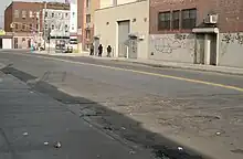
The line was out of service in January 1985.[38] Since the line was abandoned, additional plots of land along the right-of-way have been built upon or used as parking lots.[16][39][40] The remainder of the lots are vacant.[6][32][41] A private development company bought several parcels of land along the line from Conrail in 1986.[42] Some stretches of abandoned track persisted for several years: in 2000, the website Forgotten NY documented several instances of trackage that remained both on streets and in lots along the right-of-way.[40] On Hancock Street southwest of Wyckoff Avenue, a railroad crossing sign remained through the early 2000s, despite there being no visible trackage on the street.[41][40]
Station list
| Miles | Name | Opened | Closed | Notes |
|---|---|---|---|---|
| 0[43] | Greenpoint | May 16, 1878[22]: 206–207 | September 28, 1885[22]: 206–207 | |
| 0.56[43] | Fifth Street | 1878[22]: 207 | 1879[22]: 207 | |
| 0.99[43] | Humboldt Street | May 16, 1878[22]: 207 | September 28, 1885[22]: 207 | |
| 1.75[43] | Grand Street | May 16, 1878[22]: 207 | September 28, 1885[22]: 207 | |
| 2.33 | South Side Railroad Crossing | May 16, 1878 June 1886[22]: 207 |
May 25, 1881 1890[22]: 207 |
Crossing with Bushwick Branch near Varick Avenue |
| Ridgewood earlier DeKalb Avenue |
July 14, 1878[22]: 207–208 | 1894[22]: 207–208 | Renamed Ridgewood in June 1882. | |
| 3.26[43] | Myrtle Avenue | May 16, 1878[22]: 208 | May 1882[22]: 208 | |
| Base Ball Grounds[44] | 1885 | 1886 | Between Halsey and Schaeffer Streets (Wallace's Grounds/Ridgewood Base Ball Park)[45] | |
| 3.95[43] | Cooper Avenue | June 2, 1883[22]: 208 | 1894[22]: 208 | Opened as a transfer station to allow passengers from Greenpoint to get to Manhattan Beach. Located at the crossing with the Bay Ridge Branch; Also called Cooper Avenue Junction. |
See also
References
- "Taxpayers of Evergree, L.I., After The Politicians". The Brooklyn Daily Eagle. September 10, 1891. p. 2. Retrieved April 9, 2018.
- "Public Sports on Sunday: Queens County Officials Petitioned To Suppress Them". The Brooklyn Daily Eagle. March 15, 1890. p. 5. Retrieved April 9, 2018.
- Armbruster, Eugene L. (1912). The Eastern District of Brooklyn. The Library of Congress. New York : [s.n.]
- Wilkinson, Christina (July 2005). "RIDGEWOOD, Queens". forgotten-ny.com. Retrieved September 7, 2017.
- Schubel, George (1913). Illustrated history of Greater Ridgewood, together with brief sketches of its industries, organizations and biographical sketches of some of its prominent men. Allen County Public Library Genealogy Center. [Ridgewood, N.Y.] Ridgewood Times Printing and Publishing Company.
- Huneke, Arther (2015). "EVERGREEN BRANCH PAGE 3". www.arrts-arrchives.com. Retrieved September 17, 2017.
- Anderson, Bob. "Evergreen Branch". lirrhistory.com. Archived from the original on March 4, 2000. Retrieved September 7, 2017.
{{cite web}}: CS1 maint: unfit URL (link) -
- Emery, Robert. "Evergreen Branch Track Map Linden Street to Decatur Street". lirrhistory.com. Retrieved September 7, 2017.
Emery, Robert. "Evergreen Branch Track Map Jefferson Street to Linden Street". lirrhistory.com. Retrieved September 7, 2017.
Emery, Robert. "Evergreen Branch Track Map Varick Avenue to Jefferson Street". lirrhistory.com. Retrieved September 7, 2017.
- Emery, Robert. "Evergreen Branch Track Map Linden Street to Decatur Street". lirrhistory.com. Retrieved September 7, 2017.
- Ron Ziel and George H. Foster, Steel Rails to the Sunrise, ©1965
- "Valuation Reports Vol. 36 pp 79-81". rnetzlof.pennsyrr.com. Interstate Commerce Commission. 1932. Retrieved September 7, 2017.
Commission, United States Interstate Commerce (1932). Interstate Commerce Commission Reports: Decisions of the Interstate Commerce Commission of the United States. Valuation reports. U.S. Government Printing Office. pp. 79–81. - "PRR Chronology, 1874" (PDF). (95.9 KiB), March 2005 Edition
- "THE GLENDALE AND EAST RIVER ROAD". The New York Times. April 23, 1876. ISSN 0362-4331. Retrieved September 10, 2017.
- "PRR Chronology, 1876" (PDF). (116 KiB), April 2006 Edition
- "PRR Chronology, 1877" (PDF). (156 KiB), June 2006 Edition
- "P. R. R. Interests Win and Keep L. I. City Rights". Brooklyn Daily Eagle. Brooklyn, NY. May 29, 1902. p. 3. Retrieved September 7, 2017.
- Huneke, Arthur (2015). "EVERGREEN BRANCH PAGE 2". www.arrts-arrchives.com. Retrieved September 17, 2017.
- "Manhattan Beach". Brooklyn Daily Eagle. Brooklyn, NY. May 16, 1878. p. 1. Retrieved September 7, 2017.
- "Opened". Brooklyn Daily Eagle. Brooklyn, NY. May 17, 1878. p. 4.
- "Modern Urban Neighborhood: A Look at Williamsburg with a Focus on its Infrastructure". Derek Stadler. July 2, 2016. Retrieved September 10, 2017.
- Railway Locomotives and Cars. Simmons-Boardman Publishing Corporation. 1881.
- Huneke, Arthur (2009). "THE L.I.R.R.'S EVERGREEN BRANCH". arrts-arrchives.com. Retrieved September 7, 2017.
- Seyfried, Vincent (1966). The Long Island Rail Road : a comprehensive history. Part four, The Bay Ridge & Manhattan Beach Divisions ; L.I.R.R. operation on the Brighton and Culver Lines. Garden City, New York.
{{cite book}}: CS1 maint: location missing publisher (link) - Long Island Railroad Information Bulletin. February 20, 1924.
- Annual Report. Long Island Rail Road. 1916. p. 26.
- Annual Report of the Public Service Commission, Second District. The Commission. 1914.
- Anastasio, Joe (September 6, 2017). "Brooklyn's long forgotten railroad, Part 1". LTV Squad. Retrieved September 14, 2017.
- Commission, New York (State) Transit (1922). Annual Report ... J.B. Lyon Company. p. 116.
- "Evergreen Branch May Be Abandoned". Brooklyn Chamber of Commerce Bulletin. 2 (1): 11. September 18, 1920 – via Google Books.
- Apportionment, New York (N Y. ) Board of Estimate and (1924). Report of the Chief Engineer. p. 48.
- Engineering News-record. McGraw-Hill. June 26, 1913. p. 49.
- "Development of the Long Island Rail Road In The Rockaways". ERA Bulletin. Electric Railroaders' Association. 55 (6): 6. June 2012 – via Issu.
- Anastasio, Joe (September 6, 2017). "Brooklyn's long forgotten railroad, Part 2". LTV Squad. Retrieved September 14, 2017.
- The Traffic World. Traffic Service Corporation. 1983.
- The Traffic World. Traffic Service Corporation. 1983.
- Traffic World. Traffic Service Corporation. 1984.
- Traffic World. Traffic Service Corporation. 1984.
- "Metropolitan Transportation Authority Real Property Reports Covering Fiscal Year 2010" (PDF). mta.info. March 2, 2011. Retrieved September 15, 2017.
- Baer, Christopher (April 2015). "A GENERAL CHRONOLOGY OF THE SUCCESSORS OF THE PENNSYLVANIA RAILROAD COMPANY AND THEIR HISTORICAL CONTEXT 1980-1989" (PDF). prrths.com. Retrieved September 18, 2017.
- "Real Estate Round Up". wyckoffheights.org. September 30, 2014. Archived from the original on October 18, 2014. Retrieved September 7, 2017.
- Walsh, Kevin (October 2000). "EVERGREEN BRANCH: another lost LIRR line - Forgotten New York". forgotten-ny.com. Retrieved September 14, 2017.
- Boland, Ed Jr. (August 26, 2001). "F.y.i." The New York Times. ISSN 0362-4331. Retrieved September 25, 2020.
- An Assessment of the Transit Service Potential of Inactive Railroad Rights-of-way and Yards Final Report. New York City Department of City Planning. October 1991. pp. 23–25.
- "1879 REPORT TO NEW YORK STATE RAILROAD COMMISSION". arrts-arrchives.com. p. 72. Retrieved September 7, 2017.
- "LIRR Station History" (PDF). trainsarefun.com. Retrieved September 14, 2021.
- "The Parks of Ridgewood". brooklynballparks.com. Retrieved September 14, 2021.

