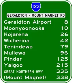
Geraldton–Mount Magnet Road
Geraldton–Mount Magnet Road is a 335-kilometre-long (208 mi)[1] major regional road in the Mid West region of Western Australia,[2] starting in Utakarra in Geraldton's eastern suburbs, and terminating 333 kilometres (207 mi) east-northeast at Great Northern Highway near the mining town of Mount Magnet. The road is signed as State Route 123, is a two-lane single carriageway for its entire length, and is a major traffic route which is regularly used by heavy vehicles and mine/grain road trains.[3]
Geraldton–Mount Magnet Road | |
|---|---|
| General information | |
| Type | Highway |
| Length | 335.34 km (208 mi) |
| Route number(s) | |
| Major junctions | |
| West end | |
| |
| East end | |
| Location(s) | |
| Major settlements | Mullewa, Pindar, Wurarga, Yalgoo, Edah |
| Highway system | |
The construction of Stage Two of the Geraldton Southern Transport Corridor is expected to remove considerable traffic from the Geraldton end of the road.

History
Prior to 2010, Geraldton-Mount Magnet Road ran through Utakarra, Rangeway and Geraldton's main industrial area and terminated at North West Coastal Highway around 450 meters north of its current intersection. Construction of a bypass began around 2007-2008 and the 8.3-kilometre-long (5.2 mi) section of the bypass opened in February 2010.
Description
Geraldton–Mount Magnet Road commences in Utakarra as a continuation of Utakarra Road, which carries State Route 123 from North West Coastal Highway 1.8 kilometres (1.1 mi) to the southwest. It heads east towards Geraldton Airport, then east-northeast through the flat-topped Moresby Ranges on its way towards the agricultural town of Mullewa. It then travels in a generally straight line through Yalgoo and ends at the Great Northern Highway 3 kilometres (2 mi) south of Mount Magnet.

Towns
Towns and settlements on this highway include:
- Deepdale
- Geraldton Airport
- Moonyoonooka
- Kojarena
- Northern Gully
- Wicherina
- Tenindewa
- Mullewa
- Pindar
- Wurarga
- Yalgoo
References
- "Road Information Mapping System". Main Roads Western Australia. Archived from the original on 28 September 2013. Retrieved 12 December 2013.
- Main Roads Western Australia (17 December 2013). "Regional Roads". Government of Western Australia. Archived from the original on 11 November 2013. Retrieved 20 December 2013.
- Shire of Greenough (17 October 2000). "Minutes of the Health Building & Town Planning Committee" (PDF). p. 11. Archived from the original (PDF) on 28 September 2007. Retrieved 22 June 2007.