Georgetown, South Australia
Georgetown is a town in the Mid North region of South Australia. The town is in the Northern Areas Council, 196 kilometres (122 mi) north of the state capital, Adelaide on the Horrocks Highway (Main North Road).
| Georgetown South Australia | |||||||||||||||
|---|---|---|---|---|---|---|---|---|---|---|---|---|---|---|---|
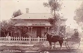
 Bank of Adelaide, Georgetown, early 1900s | |||||||||||||||
 Georgetown | |||||||||||||||
| Coordinates | 33°22′0″S 138°24′0″E | ||||||||||||||
| Population | 186 (SAL 2021)[1] | ||||||||||||||
| Postcode(s) | 5472 | ||||||||||||||
| Location |
| ||||||||||||||
| LGA(s) | Northern Areas Council | ||||||||||||||
| State electorate(s) | Frome | ||||||||||||||
| Federal division(s) | Grey | ||||||||||||||
| |||||||||||||||
Georgetown was one of the first towns to be surveyed in the upper Mid North when the Strangways Act was passed in 1869 to authorise resumption of pastoral leases to enable closer settlement for more intensive farming purposes. It was surveyed in 1869, along with Redhill.[2] It was the seat of the District Council of Georgetown from 1876 to 1988, but following two successive amalgamations with neighbouring councils, it is now part of the Northern Areas Council.[3]
Georgetown was on the Gladstone railway line from Adelaide. This was constructed in 1894 as 3 ft 6 in (1,067 mm) narrow gauge. It was converted to 5 ft 3 in (1,600 mm) broad gauge in 1927 and closed in 1988.[2]
Geography and climate
| Climate data for Georgetown | |||||||||||||
|---|---|---|---|---|---|---|---|---|---|---|---|---|---|
| Month | Jan | Feb | Mar | Apr | May | Jun | Jul | Aug | Sep | Oct | Nov | Dec | Year |
| Record high °C (°F) | 44.4 (111.9) |
41.7 (107.1) |
40.6 (105.1) |
34.7 (94.5) |
27.3 (81.1) |
26.0 (78.8) |
26.4 (79.5) |
25.2 (77.4) |
33.2 (91.8) |
36.7 (98.1) |
42.2 (108.0) |
43.4 (110.1) |
44.4 (111.9) |
| Average high °C (°F) | 31.1 (88.0) |
30.7 (87.3) |
28.1 (82.6) |
22.9 (73.2) |
18.2 (64.8) |
15.0 (59.0) |
14.2 (57.6) |
15.5 (59.9) |
18.7 (65.7) |
22.4 (72.3) |
26.2 (79.2) |
29.2 (84.6) |
22.7 (72.9) |
| Average low °C (°F) | 15.0 (59.0) |
15.2 (59.4) |
13.1 (55.6) |
9.8 (49.6) |
7.1 (44.8) |
5.1 (41.2) |
4.2 (39.6) |
4.5 (40.1) |
5.7 (42.3) |
7.8 (46.0) |
10.6 (51.1) |
13.1 (55.6) |
9.3 (48.7) |
| Record low °C (°F) | 4.0 (39.2) |
6.7 (44.1) |
2.8 (37.0) |
0.0 (32.0) |
−0.4 (31.3) |
−3.6 (25.5) |
−6.6 (20.1) |
−2.3 (27.9) |
−2.9 (26.8) |
−0.4 (31.3) |
0.6 (33.1) |
2.2 (36.0) |
−6.6 (20.1) |
| Average rainfall mm (inches) | 20.4 (0.80) |
20.8 (0.82) |
20.4 (0.80) |
35.5 (1.40) |
50.5 (1.99) |
58.4 (2.30) |
57.0 (2.24) |
56.7 (2.23) |
52.7 (2.07) |
44.7 (1.76) |
31.6 (1.24) |
26.0 (1.02) |
474.7 (18.67) |
| Average rainy days (≥ 0.2mm) | 3.1 | 2.9 | 3.6 | 6.1 | 9.2 | 11.3 | 12.4 | 12.3 | 10.0 | 7.9 | 5.5 | 4.4 | 88.7 |
| Source: Bureau of Meteorology[4] | |||||||||||||
References
- Australian Bureau of Statistics (28 June 2022). "Georgetown (SA) (Suburb and Locality)". Australian Census 2021 QuickStats. Retrieved 28 June 2022.
- Bell, Peter (1998). "The Heritage of the upper North: a short history". Professional Historians Association (South Australia). Retrieved 6 December 2015.
- "Georgetown". Northern Areas Council. Archived from the original on 4 March 2016. Retrieved 30 March 2016.
- "Georgetown". Climate statistics for Australian locations. Bureau of Meteorology. 17 January 2019. Retrieved 22 January 2019.