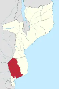
Gaza Province
Gaza is a province of Mozambique. It has an area of 75,709 km2[2] and a population of 1,422,460 (2017 census), which is the least populous of all the provinces of Mozambique.[3]
Gaza | |
|---|---|
 | |
 Gaza, Province of Mozambique | |
| Country | Mozambique |
| Capital | Xai-Xai |
| Area | |
| • Total | 75,709 km2 (29,231 sq mi) |
| Population (2017) | |
| • Total | 1,422,460 |
| • Density | 19/km2 (49/sq mi) |
| Postal code | 12xx |
| Area code(s) | (+258) 281, 282 |
| HDI (2019) | 0.449[1] low · 6th of 11 |
| Website | www |
.jpg.webp)
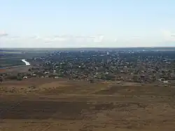
Xai-Xai is the capital of the province. Inhambane Province is to the east, Manica Province to the north, Maputo Province to the south, South Africa to the west, and Zimbabwe to the northwest.
Geography
Most of the district lies in the basin of the Limpopo River, which runs from northwest to southeast through the district, emptying into the Indian Ocean near Xai-Xai. The Changane River, a tributary of the Limpopo, forms part of the province's eastern boundary. The Rio dos Elefantes (Olifants River) flows into the district from the west through the Massingir Dam, to empty into the Limpopo.
The Save River forms the northern boundary of the province.
The Limpopo railway, which connects Zimbabwe and Botswana to the port of Maputo, runs through the province, entering Zimbabwe at the border town of Chicualacuala.
The province, including the towns of Xai-Xai and Chokwe, were greatly affected by the 2000 Mozambique flood.
Limpopo National Park lies within the province, bounded by the Elefantes and Limpopo rivers and the South African border. Banhine National Park lies in the east-central portion of the province. The Great Limpopo Transfrontier Park and its associated conservation area, which is in the process of being formed, will cover the northern part of the province, including both national parks, and extend into adjacent parts of Mozambique, South Africa, and Zimbabwe.
Districts
The province was created on October 20, 1954, when Sul do Save District was divided into the districts of Gaza, Inhambane, and Lourenço Marques (later renamed Maputo). In 1978, Mozambique's districts were renamed provinces.
Gaza Province is divided into the 14 districts of:
- Bilene Macia District
- Chibuto District
- Chicualacuala District
- Chigubo District
- Chonguene District
- Mapai District
- Chókwè District
- Guijá District
- Limpopo District Geographic Location and Establishment
Limpopo District one of the 14 Districts of Gaza Province. It was carved out of the existing district of Xai-Xai and the District of Bilene Macia in 2016, stretching from the Administrative Post of Chissano to its south and north of the city of Macia on the national EN 1 Motorway. It includes Administrative Posts Licilo, Chicumbane and others. To the north, it borders the provincial capital city of Xai Xai on the bank of Limpopo River. The districts lies in the Limpopo Basin.
Economy
The District of Limpopo is practically rural. It has no industrial economic activities of note. Subsistence farming is the order of the day.
The district capital is the borough of Trez De Fevereiro (3rd of February), a poor township without any form of development.
The district is home to the Toll Gate. Motorists pay approximately fifty metical for each trip.
Transport
The district is served by the national EN 1 Motorway.
Population
The district has approximately seven thousand inhabitants.
People and Education
Limpopo District is inhabited by the Shangaan people. The dominant languages are Shangaan and Portuguese.
Forty percent of the population can read and write. Education in the Limpopo District still requires massive investment. The majority of schools need massive construction. Many students still study under the trees. There is no proper sanitation system. It is normal for pupils and teachers to relieve themselves in the bush.
and the municipalities of
Demographics
.jpg.webp)
| Year | Pop. | ±% p.a. |
|---|---|---|
| 1980 | 990,900 | — |
| 1997 | 1,116,903 | +0.71% |
| 2007 | 1,236,284 | +1.02% |
| 2017 | 1,422,460 | +1.41% |
| source:[4] | ||
See also
References
- "Sub-national HDI - Area Database - Global Data Lab". hdi.globaldatalab.org. Retrieved 2018-09-13.
- "Estratégia de Desenvolvimento Rural (EDR)" (PDF). Retrieved 2018-01-15.
- "Resultados Preliminares IV RGPH 2017". Retrieved 2018-01-15.
- Cameroon: Administrative Division population statistics