Ganstead
Ganstead is a village in the East Riding of Yorkshire, England, in an area known as Holderness. It is situated approximately 5 miles (8 km) north-east of Hull city centre. It is divided into Ganstead East and Ganstead West by the A165 road which passes through the village.
| Ganstead | |
|---|---|
 Ganstead Location within the East Riding of Yorkshire | |
| OS grid reference | TA148341 |
| • London | 160 mi (260 km) S |
| Civil parish | |
| Unitary authority | |
| Ceremonial county | |
| Region | |
| Country | England |
| Sovereign state | United Kingdom |
| Post town | HULL |
| Postcode district | HU11 |
| Dialling code | 01482 |
| Police | Humberside |
| Fire | Humberside |
| Ambulance | Yorkshire |
| UK Parliament | |
Ganstead forms part of the civil parish of Bilton.
In 1823 Ganstead was in the parish of Swine and in the Wapentake and Liberty of Holderness. Population at the time was 61 and included four farmers and a corn miller.[1]
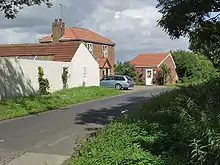
Swine Lane, Ganstead West
References
- Baines, Edward (1823): History, Directory and Gazetteer of the County of York, p. 209
- Gazetteer – A–Z of Towns Villages and Hamlets. East Riding of Yorkshire Council. 2006. p. 6.
External links
 Media related to Ganstead at Wikimedia Commons
- Ganstead in the Domesday Book
| Unitary authorities | |
|---|---|
| Major settlements (cities in italics) | |
| Rivers | |
| Canals | |
| Topics | |
This article is issued from Wikipedia. The text is licensed under Creative Commons - Attribution - Sharealike. Additional terms may apply for the media files.