Fuchū, Hiroshima
Fuchū (府中市, Fuchū-shi) is a city located in Hiroshima Prefecture, Japan. As of 1 April 2023, the city had an estimated population of 36,326 in 17013 households and a population density of 190 persons per km2.[1] The total area of the city is 195.75 square kilometres (75.58 sq mi).
Fuchū
府中市 | |
|---|---|
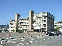
 Fuchū City Hall | |
 Flag  Emblem | |
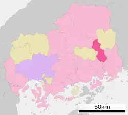
Location of Fuchu in Hiroshima Prefecture | |
 | |
 Fuchū Location in Japan | |
| Coordinates: 34°33′54″N 133°14′31″E | |
| Country | Japan |
| Region | Chūgoku (San'yō) |
| Prefecture | Hiroshima |
| Government | |
| • Mayor | Shinji Ono (since May 2008) |
| Area | |
| • Total | 195.75 km2 (75.58 sq mi) |
| Population (April 1, 2023) | |
| • Total | 36,326 |
| • Density | 190/km2 (480/sq mi) |
| Time zone | UTC+09:00 (JST) |
| City hall address | 315 Fukawacho, Fuchu-shi, Hiroshima-ken 726-8601 |
| Climate | Cfa |
| Website | Official website |
| Symbols | |
| Flower | Hydrangea |
| Tree | Cherry blossom |


Geography
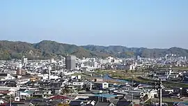
Fuchū is located in the basin of the Ashida River in eastern Hiroshima.
Climate
Fuchū has a humid subtropical climate (Köppen climate classification Cfa) characterized by cool to mild winters and hot, humid summers. The average annual temperature in Fuchū is 15.0 °C (59.0 °F). The average annual rainfall is 1,257.7 mm (49.52 in) with July as the wettest month. The temperatures are highest on average in August, at around 27.2 °C (81.0 °F), and lowest in January, at around 3.6 °C (38.5 °F).[2] The highest temperature ever recorded in Fuchū was 38.6 °C (101.5 °F) on July 28, 2023; the coldest temperature ever recorded was −9.9 °C (14.2 °F) on 27 February 1981.[3]
| Climate data for Fuchū (1991−2020 normals, extremes 1979−present) | |||||||||||||
|---|---|---|---|---|---|---|---|---|---|---|---|---|---|
| Month | Jan | Feb | Mar | Apr | May | Jun | Jul | Aug | Sep | Oct | Nov | Dec | Year |
| Record high °C (°F) | 16.5 (61.7) |
22.2 (72.0) |
25.3 (77.5) |
30.5 (86.9) |
32.8 (91.0) |
35.2 (95.4) |
38.7 (101.7) |
38.5 (101.3) |
37.6 (99.7) |
31.9 (89.4) |
25.2 (77.4) |
19.4 (66.9) |
38.7 (101.7) |
| Average high °C (°F) | 8.8 (47.8) |
10.0 (50.0) |
13.9 (57.0) |
19.8 (67.6) |
24.7 (76.5) |
27.5 (81.5) |
31.2 (88.2) |
32.9 (91.2) |
28.7 (83.7) |
22.9 (73.2) |
16.8 (62.2) |
11.1 (52.0) |
20.7 (69.2) |
| Daily mean °C (°F) | 3.6 (38.5) |
4.4 (39.9) |
7.8 (46.0) |
13.3 (55.9) |
18.3 (64.9) |
22.1 (71.8) |
26.1 (79.0) |
27.2 (81.0) |
23.1 (73.6) |
17.0 (62.6) |
10.9 (51.6) |
5.7 (42.3) |
15.0 (58.9) |
| Average low °C (°F) | −0.7 (30.7) |
−0.4 (31.3) |
2.2 (36.0) |
7.2 (45.0) |
12.5 (54.5) |
17.7 (63.9) |
22.1 (71.8) |
22.9 (73.2) |
18.8 (65.8) |
12.2 (54.0) |
5.9 (42.6) |
1.2 (34.2) |
10.1 (50.3) |
| Record low °C (°F) | −8.0 (17.6) |
−9.9 (14.2) |
−5.0 (23.0) |
−2.4 (27.7) |
1.5 (34.7) |
9.2 (48.6) |
13.4 (56.1) |
14.9 (58.8) |
6.6 (43.9) |
0.6 (33.1) |
−1.8 (28.8) |
−6.0 (21.2) |
−9.9 (14.2) |
| Average precipitation mm (inches) | 40.6 (1.60) |
49.5 (1.95) |
88.9 (3.50) |
100.7 (3.96) |
130.3 (5.13) |
185.1 (7.29) |
210.4 (8.28) |
111.6 (4.39) |
140.6 (5.54) |
93.7 (3.69) |
59.4 (2.34) |
47.1 (1.85) |
1,257.7 (49.52) |
| Average precipitation days (≥ 1.0 mm) | 5.8 | 7.6 | 9.5 | 9.4 | 9.3 | 11.2 | 10.5 | 7.5 | 8.7 | 6.9 | 6.4 | 6.8 | 99.6 |
| Mean monthly sunshine hours | 136.4 | 139.4 | 174.3 | 193.3 | 209.4 | 148.5 | 167.0 | 196.5 | 153.4 | 167.5 | 148.3 | 138.2 | 1,984.5 |
| Source: Japan Meteorological Agency[2][3] | |||||||||||||
Demographics
Per Japanese census data, the population of Fuchū in 2020 is 37,655 people.[4] Fuchū has been conducting censuses since 1960.
| Year | Pop. | ±% |
|---|---|---|
| 1960 | 54,327 | — |
| 1965 | 57,216 | +5.3% |
| 1970 | 58,364 | +2.0% |
| 1975 | 57,625 | −1.3% |
| 1980 | 56,209 | −2.5% |
| 1985 | 54,939 | −2.3% |
| 1990 | 52,692 | −4.1% |
| 1995 | 50,356 | −4.4% |
| 2000 | 47,697 | −5.3% |
| 2005 | 45,188 | −5.3% |
| 2010 | 42,557 | −5.8% |
| 2015 | 40,069 | −5.8% |
| 2020 | 37,655 | −6.0% |
| Fuchū population statistics[4] | ||
History
The area of Fuchū was part on ancient Bingo Province, and was the site of the Nara period Bingo Provincial Capital. During then Edo Period, it was largely the territory of Fukuyama Domain. Following the Meiji restoration, the village of Fuchūichi was established with the creation of the modern municipalities system on April 1, 1889. It became the town of Fuchū on June 3, 1896. Fuchū was raised to city status on March 31, 1954. On April 1, 2004, the town of Jōge (from Kōnu District) was merged into Fuchū.[5]
Government
Fuchū has a mayor-council form of government with a directly elected mayor and a unicameral city council of 20 members. Fuchū contributes one member to the Hiroshima Prefectural Assembly. In terms of national politics, the city is part of the Hiroshima 6th district of the lower house of the Diet of Japan.
Economy
Fuchū is an inland industrial city. Furniture making as a local industry has a tradition from the Edo period and in particular, the Fuchū chest-of-drawers made of paulownia wood remains famous. It is also the production area of 'Fuchū Miso'. Cotton farming and processing, textiles and dying, tobacco farming and die-cast metal products contribute to the economy.
Education
Fuchū has six public elementary schools, two public junior high schools and two public combined elementary/middle schools operated by the city government, and three public high schools operated by the Hiroshima Prefectural Board of Education.
Transportation
Railway
![]() JR West (JR West) - Fukuen Line
JR West (JR West) - Fukuen Line
- Takagi - Ukai - Fuchū - Shimo-Kawabe - Nakahata - Kawasa - Bingo-Mikawa - Bingo-Yano - Jōge
Highways
References
- "Fuchū city official statistics" (in Japanese). Japan.
- 気象庁 / 平年値(年・月ごとの値). JMA. Retrieved May 13, 2022.
- 観測史上1~10位の値(年間を通じての値). JMA. Retrieved May 13, 2022.
- Fuchū population statistics
- "Fuchu details". hiroshima-navi.or.jp. Retrieved 13 November 2019.
External links
- Fuchū City official website (in Japanese)