Fremont Bridge (Seattle)
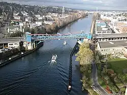
The Fremont Bridge is a double-leaf bascule bridge that spans the Fremont Cut in Seattle, Washington. The bridge, which connects Fremont Avenue North and 4th Avenue North, connects the neighborhoods of Fremont and Queen Anne.
Fremont Bridge | |
|---|---|
 The Fremont Bridge from the George Washington Memorial Bridge | |
| Coordinates | 47°38′51″N 122°21′00″W |
| Carries | Fremont Avenue N |
| Crosses | Fremont Cut |
| Locale | Seattle, Washington |
| Maintained by | Seattle Department of Transportation |
| Characteristics | |
| Design | bascule |
| Total length | 502 feet (153 m) |
| Longest span | 242 feet (74 m) |
| Clearance below | 30 feet (9.1 m) |
| History | |
| Opened | June 15, 1917 |
| Designated | December 28, 1981[1] |
Fremont Bridge | |
| Location | Spans Lake Washington Ship Canal, Seattle, Washington |
| Area | less than one acre |
| Built | 1917 |
| Engineer | Arthur H. Dimock[2] |
| MPS | Historic Bridges/Tunnels in Washington State TR |
| NRHP reference No. | 82004234[3] |
| Added to NRHP | July 16, 1982 |
| Location | |
The Fremont Bridge was opened on Friday June 15, 1917, at a cost of $410,000.[4] The first traffic over the bridge was to "owl cars", the last run of the trolleys, and then after 5am the same day to all other traffic. The Lake Washington Ship Canal was dedicated on July 4, 1917, which has caused confusion about the opening date, for this bridge crosses the canal.[5]
The Fremont Bridge is the first of four city bascules to cross the canal, the others being Ballard Bridge (1917), University Bridge (1919), and Montlake Bridge (1925). The bridge was added to the National Register of Historic Places in 1982, and is also a designated city landmark, ID #110347.[1]
In its early years, before the construction of the nearby Aurora Bridge in 1932, the Fremont Bridge had the most vehicle traffic of any bascule bridge in the United States.[6] In another respect, it remains among the busiest even today: due to its low vessel clearance of 30 feet (9.1 m),[7] the Fremont Bridge opens an average of 35 times a day, which makes it the most frequently opened drawbridge in the United States[8] and one of the busiest bascule bridges in the world.[9] Federal law gives marine traffic the right-of-way over vehicular traffic; however, the Fremont Bridge is closed to most water traffic during rush hours.[7]
The Fremont Bridge was originally painted a dull green.[2] In 1972, the Fremont Improvement Committee picked a new color, Fremont Orange, and residents approved the change.[2] The bridge's blue and orange color was chosen by voters at a 1985 street fair.[10]
In 2006, the Fremont Bridge underwent a $41.9 million restoration project to replace the approaches and maintenance shop, as well as renovation of the mechanical and electrical systems that operate the bascule.[11] The approaches were completed in May 2007[12] and testing lasted through the Spring of 2008.[13] In 2014 the city began repainting the bridge.[14]
The bridge received a permanent art installation in February 2018 as part of an artist residency program coinciding with the centennial of the bridge and two of the ship canal's other bascule bridges. The Fremont Bridge was outfitted with what is to be the first of three dynamic lighting designs. The Ballard Bridge and University Bridge will also receive installations assuming funding can be secured.[15]
A bicycle counter was installed in 2012.[16] It was the first of twelve counters in the city, as of 2018.[17] Bike traffic reached 1.12 million rides in 2019, a 13% increase from the year before.[18]
Earlier bridges
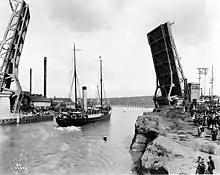
The present bridge is actually the third bridge at this location. A low trestle bridge was built in 1890 or 1891. In 1911, in anticipation of the construction of the Ship Canal, it was replaced by a higher trestle bridge. While that bridge was always intended as temporary, it proved even more so than planned, because early in the afternoon of March 12, 1914, the Fremont dam, which controlled the level of Lake Union, gave way. Over the course of a day, the lake level lowered by nine feet, stranding vessels and floating homes, and rupturing the central portion of the second Fremont bridge. The Stone Avenue Bridge, which included a streetcar trestle from Westlake Avenue to Stone Way, remained intact. Streetcar traffic that had used the Fremont Bridge was rerouted over that trestle until the completion of the present-day bridge.[6]

References
- "Ordinance 110347" (PDF). City of Seattle. December 28, 1981. Retrieved October 14, 2019.
- Drosendahl, Glenn (June 11, 2017). "Fremont Bridge (Seattle)". HistoryLink. Retrieved October 14, 2019.
- "National Register Information System". National Register of Historic Places. National Park Service. July 9, 2010.
- Holstine, Craig E.; Hobbs, Richard (2005). Spanning Washington: Historic Highway Bridges of the Evergreen State. Washington State University Press. pp. 103–104. ISBN 0-87422-281-8.
- "Lake Washington Ship Canal". seattle.gov. Retrieved October 14, 2019.
- Dorpat, Paul (June 7, 2014). "Seattle Now & Then: The Lake Union Dam Washout". pauldorpat.com. Retrieved December 21, 2018.
- "Bridges and Roadway Structures: Bridge Openings". Seattle Department of Transportation. Retrieved January 23, 2010.
- "Fremont Bridge". Atlas Obscura. Retrieved May 17, 2018.
- Long, Priscilla (March 23, 2001). "Seattle's Fremont Bridge opens to traffic on June 15, 1917". HistoryLink. Retrieved October 14, 2019.
- Broom, Jack (July 5, 2002). "Big for our bridges". The Seattle Times. Retrieved May 20, 2007.
- "Fremont Bridge will close overnight this week". Seattle Post-Intelligencer. May 13, 2007. Retrieved May 20, 2007.
- "All Lanes Of Fremont Bridge Open". KIRO. May 18, 2007. Archived from the original on September 27, 2007. Retrieved May 20, 2007.
- "Fremont Bridge Approaches Replacement Project". Seattle Department of Transportation. Archived from the original on March 17, 2007. Retrieved May 20, 2007.
- "Safely Painting the Fremont Bridge". Seattle Department of Transportation. Retrieved February 5, 2015.
- Lloyd, Sarah Anne (February 8, 2018). "Fremont Bridge light show celebrates multi-bridge centennial". Curbed Seattle. Vox Media. Retrieved February 28, 2018.
- Gutierrez, Scott (October 10, 2012). "Bike counter installed at Fremont Bridge". Seattle Post-Intelligencer. Retrieved October 15, 2021.
- Baruchman, Michelle (August 20, 2018). "What we can learn from Seattle's bike-counter data". The Seattle Times. Retrieved October 14, 2021.
- Baruchman, Michelle (January 6, 2020). "Bike ridership hits record highs on 2 Seattle routes". The Seattle Times. Retrieved October 15, 2021.
External links
Archives
- William C. Ruegnitz Papers. 1906-1944. 1.68 cubic feet (5 boxes). At the Labor Archives of Washington, University of Washington Libraries Special Collections. Contains details about the location, list of materials and their estimated cost of the Fremont Bridge.

