Freeport station (LIRR)
The Freeport station is a station on the Babylon Branch of the Long Island Rail Road. It is located in Freeport Plaza between Henry Street and Benson Place, just north of NY 27 in Freeport, New York.
Freeport | ||||||||||||||||
|---|---|---|---|---|---|---|---|---|---|---|---|---|---|---|---|---|
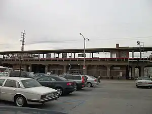
 Freeport station as seen from part of the parking lot | ||||||||||||||||
| General information | ||||||||||||||||
| Location | Freeport Plaza Freeport, New York | |||||||||||||||
| Coordinates | 40.657425°N 73.582601°W | |||||||||||||||
| Owned by | Long Island Rail Road | |||||||||||||||
| Line(s) | Montauk Branch | |||||||||||||||
| Distance | 22.7 mi (36.5 km) from Long Island City[1] | |||||||||||||||
| Platforms | 1 island platform | |||||||||||||||
| Tracks | 2 | |||||||||||||||
| Connections | ||||||||||||||||
| Construction | ||||||||||||||||
| Parking | Yes | |||||||||||||||
| Accessible | Yes | |||||||||||||||
| Other information | ||||||||||||||||
| Fare zone | 7 | |||||||||||||||
| History | ||||||||||||||||
| Opened | 1867 (SSRRLI) | |||||||||||||||
| Rebuilt | 1899, 1959–1960 | |||||||||||||||
| Electrified | May 20, 1925 750 V (DC) third rail | |||||||||||||||
| Passengers | ||||||||||||||||
| 2012—2014 | 5,629[2] | |||||||||||||||
| Rank | 21 of 125 | |||||||||||||||
| Services | ||||||||||||||||
| ||||||||||||||||
| ||||||||||||||||
History
The Freeport station was originally built on October 28, 1867 by the South Side Railroad of Long Island, and was rebuilt in 1899. It is among many of the stations along the Babylon Branch that were elevated throughout Nassau and Western Suffolk counties during the 1960s, in this case October 1960.[3][4]
Some afternoon rush-hour trains terminate at Freeport and some morning rush-hour trains originate at Freeport.
The station is served by several different Nassau Inter-County Express routes, including service to Jones Beach.[5][6]
Station layout
The station has one 12-car-long high-level island platform between the two tracks. There are two layover tracks east of the station.
Image gallery
- Freeport station
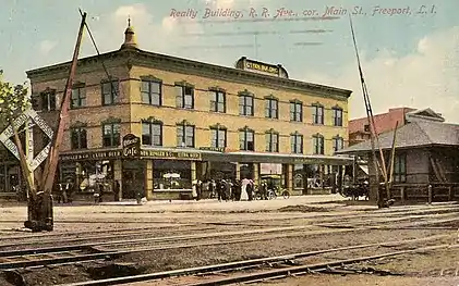
 Early 20th century postcard of the station in the shadow of the Otten Building
.jpg.webp) The Nassau Inter-County Express N4 bus to Jamaica
The Nassau Inter-County Express N4 bus to Jamaica
References
- Long Island Rail Road (May 14, 2012). "TIMETABLE No. 4" (PDF). p. IV. Retrieved August 4, 2022.
- "2012-2014 LIRR Origin and Destination Report : Volume I: Travel Behavior Among All LIRR Passengers" (PDF). Metropolitan Transportation Authority. August 23, 2016. PDF pp. 15, 197. Archived (PDF) from the original on July 17, 2019. Retrieved March 29, 2020.
Data collection took place after the pretest determinations, starting in September 2012 and concluding in May 2014. .... 2012-2014 LIRR O[rigin and ]D[estination] COUNTS: WEEKDAY East/West Total By Station in Numerical Order
- "New Freeport Railroad Station dedicated October 8th by Governor Rockefeller". Freeport, The Friendly Village, Your Home Town. Vol. 10, no. 10. Village of Freeport. October 1960. p. 1. Retrieved March 29, 2020 – via New York Heritage | Empire State Library Network.
Gov. Rockefeller, Speaker Carlino, County, Town and Village officials, officially opened Freeport's Grade Crossing Elimination Project with appropriate ceremonies, October 8th at 11:00 A. M. ... Completion of escalator at Railroad Station being delayed due to strike of Erector's Union since August 1, 1960
- "TOP PERSONALITIES LAUNCH NEW FREEPORT R.R. GRADE ELIMINATION". The LEADER. Freeport, NY: L & M Publications. October 13, 1960. pp. 1, 4. Retrieved March 29, 2020.
Leading dignitaries from the State of New York, Nassau County, the Long Island Railroad and the Village of Freeport Joined together last Saturday to officially launch the new Freeport Railroad Station and Grade elimination project.
- "Nassau Inter-County Express Bus Route Map, July, 2020". Nassau Inter-County Express (NICE). Retrieved August 9, 2020.
- "Nassau Inter-County Express - Maps and Schedules". www.nicebus.com. Retrieved August 10, 2020.
External links
- Freeport – LIRR
- Freeport LIRR timetable
- March 2000 Photo[Usurped!] (Unofficial LIRR Photo)
- PORT Interlocking (The LIRR Today)
- Main Street entrance from Google Maps Street View