Erattayar
Erattayar is a village in Udumbanchola taluk of Idukki district in the Indian state of Kerala.[1] It is the administrative centre of Erattayar panchayat which belongs to Kattappana block panchayat.[2]
Erattayar | |
|---|---|
Village | |
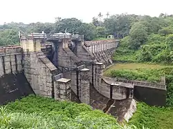
 A diversion dam near Erattayar for supplying water to Idukki reservoir | |
 Erattayar Location in Kerala, India  Erattayar Erattayar (India) | |
| Coordinates: 9°47′51″N 77°6′18″E | |
| Country | |
| State | Kerala |
| District | Idukki |
| Taluk | Udumbanchola |
| Government | |
| • Type | Panchayat |
| • Body | Erattayar Grama Panchayat |
| • Panchayat president | Jinson Varkey |
| • Vice president | Bincy Johny |
| Area | |
| • Total | 32.37 km2 (12.50 sq mi) |
| Population (2011) | |
| • Total | 19,097 |
| • Density | 590/km2 (1,500/sq mi) |
| Languages | |
| • Official | Malayalam, English |
| Time zone | UTC+5:30 (IST) |
| PIN | 685514 |
| Area code | 04868 |
| Vehicle registration | KL-69, KL-06 |
| Nearest towns | Kattappana, Nedumkandam |
| Assembly constituency | Udumbanchola |
| Website | www |
Location
Erattayar town is located 2 km (1.2 mi) south to Erattayar dam, a diversion dam built to supply water to Idukki reservoir.[3] Kattappana (5.5 km (3.4 mi)), Kumily (32 km (20 mi)), Nedumkandam (13 km (8.1 mi)), Thakamani (11 km (6.8 mi)), and Valiyathovala (2.5 km (1.6 mi)) are some of the nearby towns.
Demographics
As of 2011 India census, Erattayar had a population of 19,097 with 9,607 males and 9,490 females. Erattayar village has an area of 32.37 km2 (12.50 sq mi) with 4,539 families residing in it.[4]
Erattayar panchayat
Erattayar grama panchayat was formed in 1971.[5] The panchayat consists of 14 electoral wards.[6] It is bounded by Pampadumpara panchayat in the east, Kamakshi panchayat in the west, Kattappana municipality in the south and Nedumkandam panchayat in the north.
Ward details of Erattayar panchayat
| Ward Number | Ward Name |
|---|---|
| 1 | Chempakapara |
| 2 | Eattithoppu |
| 3 | Pallickanam |
| 4 | Erattayar North |
| 5 | Ezhukumvayal |
| 6 | Kattadikkavala |
| 7 | Erattayar |
| 8 | Santhigram South |
| 9 | Uppukandam |
| 10 | Thulasippara |
| 11 | Vazhavara |
| 12 | Nalumukku |
| 13 | Santhigram |
| 14 | Idinjamala |
Educational institutions
- St. Thomas Higher Secondary School
- St. Thomas Upper and Lower Primary Schools
- St. Thomas Nursery School
Public transport facilities
Erattayar is well-connected to nearby towns and villages through public transport facilities. Frequent private bus services are available to towns like Kattappana, Nedumkandam, Thankamani, Cheruthoni. State-owned KSRTC buses are also available to different places. There is a small bus station in the town which is mostly visited and used by local people.
See also
References
- "Village (गाव): Erattayar (ഇരട്ടയാർ )". localbodydata.com. Retrieved 2023-06-15.
- "Revenue Portal". village.kerala.gov.in. Retrieved 2023-06-15.
- "ERATTAYAR DAM – KSEB Limted Dam Safety Organisation". Retrieved 2023-06-15.
- "ഇടുക്കി ജില്ലയിലെ ജനസംഖ്യ വിവരങ്ങള് | Deparyment of Panchayats". dop.lsgkerala.gov.in. Retrieved 2023-06-15.
- Keralam, Digital. "Erattayar Grama Panchayath Erattayar Idukki Kerala India". Digital Keralam. Retrieved 2023-06-15.
- "Local Self Government Department | Local Self Government Department". lsgkerala.gov.in. Retrieved 2023-06-15.