Elter Water
Elter Water is a small lake in the Lake District in North West England, half a mile southeast of the village of the same name. It has a length of 0.62 miles (1.00 km), maximum width of approximately 0.24 miles (0.39 km), a maximum depth of 7 metres (7.7 yd), and an area of 0.16 square kilometres (0.062 sq mi). Its outflow is the River Brathay, which flows south to join Windermere near Ambleside.[1] Windermere is itself drained by the River Leven, which flows into Morecambe Bay. The lake is in the unitary authority of Westmorland and Furness and the ceremonial county of Cumbria.
| Elter Water | |
|---|---|
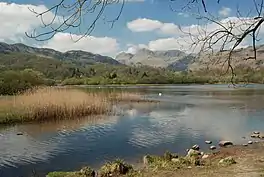 Elter Water with the Langdale Pikes in the background | |
 Elter Water Location in the Lake District National Park 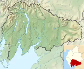 Elter Water Location in South Lakeland, Cumbria | |
| Location | Lake District, Cumbria |
| Coordinates | 54.427469°N 3.025875°W |
| Type | Tarn |
| Primary inflows | River Brathay, Langdale Beck |
| Primary outflows | River Brathay |
| Basin countries | United Kingdom |
| Max. length | 1,030 yd (940 m) |
| Max. width | 350 yd (320 m) |
| Surface area | 0.06 sq mi (0.16 km2) |
| Max. depth | 20 ft (6.1 m) |
| Shore length1 | 2.9 km (1.8 mi) |
| Surface elevation | 187 ft (57 m) |
| Islands | 2 |
| 1 Shore length is not a well-defined measure. | |
Elter Water forms part of the boundary between the historic counties of Lancashire and Westmorland, and is the northernmost point of the former.
Etymology
The name Elterwater means either
- Lake of the Swan (" 'The lake frequented by swans', from Old Norse 'elptr'/'alpt' 'swan', in the genitive sing.[ular] form with '-ar', and 'water', probably replacing Old Norse 'vatn' 'lake'. Whooper swans still winter on the lake")[2]
- or Lake of Alder.[1]
Ecology
The lake is a Site of Special Scientific Interest, but there have been problems with water quality, in particular eutrophication.[3] Navigation is prohibited on the lake.[1]
Cultural references
Thomas Frederick Worrall painted a watercolour of the lake with Langdale Pikes in the background. This painting is hanging in the Bishop's House, Keswick.
References
- Parker, 2004, page 37
- Whaley, Diana (2006). A dictionary of Lake District place-names. Nottingham: English Place-Name Society. pp. lx, 423 p.108–109. ISBN 0904889726.
- Hodges, Maureen. "Restoration project see Great Langdale Beck reconnected". Westmorland Gazette. Retrieved 13 December 2021.
Bibliography
- Parker, John Wilson (2004). An Atlas of the English Lakes. Cicerone Press. ISBN 1-85284-355-1.