Ell, Netherlands
Ell (Limburgish: Èl) is a village in the Dutch province of Limburg. It is a part of the municipality of Leudal and lies about 7 km southeast of Weert.
Ell
| |
|---|---|
Village | |
.jpg.webp) St Antonius Abt Church | |
 Ell Location in the Netherlands  Ell Location in the province of Limburg in the Netherlands | |
| Coordinates: 51°13′N 5°48′E | |
| Country | Netherlands |
| Province | Limburg |
| Municipality | Leudal |
| Area | |
| • Total | 10.97 km2 (4.24 sq mi) |
| Elevation | 29 m (95 ft) |
| Population (2021)[1] | |
| • Total | 1,470 |
| • Density | 130/km2 (350/sq mi) |
| Time zone | UTC+1 (CET) |
| • Summer (DST) | UTC+2 (CEST) |
| Postal code | 6010-6011[1] |
| Dialing code | 0495 |
| Major roads | A2 |
History
It was first mentioned in 1244 as Elle. The etymology is unknown.[3] Ell developed in the Late Middle Ages along the Tungelroyse Beek.[4] It was part of the Imperial Abbey of Thorn, a tiny independent country, until 1794.[5]
The Catholic St Antonius Abt Church is a three aisled basilica-like church built in 1912 to replace a church from 1823. The tower was blown up in 1944, and the church was restored in 1946. In 1953, a new tower was added.[4]
Ell was home to 297 people in 1840.[5]
Gallery
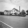 Former dairy factory
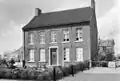 House in Ell
References
- "Kerncijfers wijken en buurten 2021". Central Bureau of Statistics. Retrieved 25 April 2022.
- "Postcodetool for 6011NA". Actueel Hoogtebestand Nederland (in Dutch). Het Waterschapshuis. Retrieved 25 April 2022.
- "Ell - (geografische naam)". Etymologiebank (in Dutch). Retrieved 25 April 2022.
- Sabine Broekhoven, & Ronald Stenvert (2003). Ell (in Dutch). Zwolle: Waanders. ISBN 90 400 9623 6. Retrieved 25 April 2022.
- "Ell". Plaatsengids (in Dutch). Retrieved 25 April 2022.
This article is issued from Wikipedia. The text is licensed under Creative Commons - Attribution - Sharealike. Additional terms may apply for the media files.