Electoral district of North Bourke
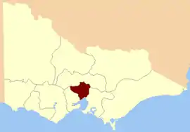
The Electoral district of North Bourke was one of the original sixteen electoral districts[1] of the old unicameral Victorian Legislative Council of 1851 to 1856. Victoria being a colony in Australia at the time.
| North Bourke Victoria—Legislative Council | |
|---|---|
 Location in Victoria | |
| State | Victoria |
| Created | 1851 |
| Abolished | 1856 |
| Demographic | Rural |
The district's area was defined as: "Bounded on the north by the great dividing range from the source of the River Plenty to the source of the Werribee River on the west by the Werribee River to Port Phillip Bay on the south by Port Phillip Bay to the mouth of the Yarra Yarra River and by that river to the confluence of the River Plenty and on the east by the River Plenty to its head in the great dividing range."[1]
From 1856 onwards, the Victorian parliament consisted of two houses, the Victorian Legislative Council (upper house, consisting of Provinces) and the Victorian Legislative Assembly (lower house).[2]
Members
Two members initially, three from the expansion of the Council in 1853.[3]
| Member 1 | Term | Member 2 | Term | ||
|---|---|---|---|---|---|
| Charles Dight | Nov. 1851 – Oct. 1852[d] | John Smith | Nov. 1851 – May? 1853[r] | Member 3 | Term |
| William Nicholson | Nov. 1852[b] – Mar. 1856 | William Burnley | Aug. 1853[b] – Mar. 1856 | George Annand | Aug. 1853 – July 1855[r] |
| Thomas Embling | Sep. 1855 – Mar. 1856 |
See also
Notes
- b = by-election
- d = died in office
- r = resigned
- Smith went on to represent the City of Melbourne in the Victorian Legislative Council from May 1853.[4]
- Embling went on to represent Collingwood in the Victorian Legislative Assembly from November 1856.[4]
- Nicholson represented The Murray in the Victorian Legislative Assembly from January 1859.[4]
References
- "Victorian Electoral Act" (PDF). New South Wales Government. Retrieved 20 May 2013.
- Sweetman, Edward (1920). Constitutional Development of Victoria, 1851-6. Whitcombe & Tombs Limited. p. 182. Retrieved 20 May 2013.
- Sweetman, p.108
- "Re-Member (Former Members)". State Government of Victoria. Retrieved 20 May 2013.