El Peñón Formation
The El Peñón Formation (Spanish: Formación El Peñón, Kipe) is a geological formation of the Altiplano Cundiboyacense, Eastern Ranges of the Colombian Andes. The formation consists of calcareous shales and siltstones and dates to the Early Cretaceous period; Late Aptian epoch and has a measured thickness at its type section of 381 metres (1,250 ft). Ammonite fossils have been found in the formation, deposited in a shallow marine platform environment.
| El Peñón Formation | |
|---|---|
| Stratigraphic range: Late Aptian ~ | |
| Type | Geological formation |
| Unit of | Villeta Group |
| Underlies | Capotes Formation |
| Overlies | Trincheras Formation |
| Thickness | more than 381 m (1,250 ft) |
| Lithology | |
| Primary | Calcareous shale |
| Other | Siltstone, gypsum |
| Location | |
| Coordinates | 5°15′13″N 74°20′28″W |
| Region | Altiplano Cundiboyacense Eastern Ranges, Andes |
| Country | |
| Type section | |
| Named for | El Peñón |
| Named by | Ulloa |
| Location | El Peñón |
| Year defined | 1982 |
| Coordinates | 5°15′13″N 74°20′28″W |
| Region | Cundinamarca |
| Country | |
| Thickness at type section | 381 m (1,250 ft) |
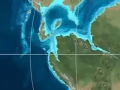 Paleogeography of Northern South America 120 Ma, by Ron Blakey | |
Etymology
The formation was defined and named in 1982 by Ulloa after El Peñón, Cundinamarca.[1]
Description
Lithologies
The El Peñón Formation has at is type section a thickness of 381 metres (1,250 ft),[2] and is characterised by a sequence of calcareous shales and siltstones. The middle part of the sequence contains gypsum.[3] Fossils of the ammonites Cheloniceras sp. and Epicheloniceras sp. aff. carlosacostai have been found in the El Peñón Formation.[1]
Stratigraphy and depositional environment
The El Peñón Formation, part of the Villeta Group, conformably overlies the Trincheras Formation and is conformably overlain by the Capotes Formation.[4] The age has been estimated to be Late Aptian.[1] Stratigraphically, the formation is time equivalent with the Tablazo Formation and a lateral facies equivalent of the Socotá Formation.[5] The formation has been deposited in a shallow marine platform environment.[1] In the Late Aptian, central Colombia was dominated by shallow marine carbonate platform environments.[6]
Outcrops
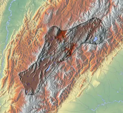
The El Peñón Formation, restricted to Cundinamarca, is locally found around its type locality,[1] between Bituima and Guayabal de Síquima,[7] and along the road from Villeta to Sasaima.[2]
Regional correlations
| Age | Paleomap | VMM | Guaduas-Vélez | W Emerald Belt | Villeta anticlinal | Chiquinquirá- Arcabuco | Tunja- Duitama | Altiplano Cundiboyacense | El Cocuy | ||||
|---|---|---|---|---|---|---|---|---|---|---|---|---|---|
| Maastrichtian | 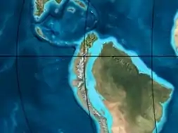 | Umir | Córdoba | Seca | eroded | Guaduas | Colón-Mito Juan | ||||||
| Umir | Guadalupe | ||||||||||||
| Campanian | Córdoba | ||||||||||||
| Oliní | |||||||||||||
| Santonian | La Luna | Cimarrona - La Tabla | La Luna | ||||||||||
| Coniacian | Oliní | Villeta | Conejo | Chipaque | |||||||||
| Güagüaquí | Loma Gorda | undefined | La Frontera | ||||||||||
| Turonian | 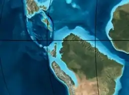 | Hondita | La Frontera | Otanche | |||||||||
| Cenomanian | Simití | hiatus | La Corona | Simijaca | Capacho | ||||||||
| Pacho Fm. | Hiló - Pacho | Churuvita | Une | Aguardiente | |||||||||
| Albian | 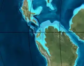 | Hiló | Chiquinquirá | Tibasosa | Une | ||||||||
| Tablazo | Tablazo | Capotes - La Palma - Simití | Simití | Tibú-Mercedes | |||||||||
| Aptian | Capotes | Socotá - El Peñón | Paja | Fómeque | |||||||||
| Paja | Paja | El Peñón | Trincheras | Río Negro | |||||||||
| La Naveta | |||||||||||||
| Barremian | | ||||||||||||
| Hauterivian | Muzo | Cáqueza | Las Juntas | ||||||||||
| Rosablanca | Ritoque | ||||||||||||
| Valanginian | Ritoque | Furatena | Útica - Murca | Rosablanca | hiatus | Macanal | |||||||
| Rosablanca | |||||||||||||
| Berriasian | 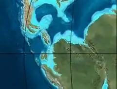 | Cumbre | Cumbre | Los Medios | Guavio | ||||||||
| Tambor | Arcabuco | Cumbre | |||||||||||
| Sources | |||||||||||||
See also
References
- Acosta & Ulloa, 2002, p.42
- Acosta & Ulloa, 2001, p.27
- Acosta & Ulloa, 2001, p.29
- Acosta & Ulloa, 2001, p.30
- Acosta & Ulloa, 2001, p.16
- Villamil, 2012, p.164
- Plancha 227, 1998
Bibliography
- Acosta Garay, Jorge E., and Carlos E. Ulloa Melo. 2002. Mapa Geológico del Departamento de Cundinamarca - 1:250,000 - Memoria explicativa, 1–108. INGEOMINAS. Accessed 2017-04-26.
- Acosta Garay, Jorge, and Carlos E. Ulloa Melo. 2001. Geología de la Plancha 208 Villeta - 1:100,000, 1-84. INGEOMINAS. Accessed 2017-06-05.
- Villamil, Tomas. 2012. Chronology Relative Sea Level History and a New Sequence Stratigraphic Model for Basinal Cretaceous Facies of Colombia, 161–216. Society for Sedimentary Geology (SEPM).
Maps
- Ulloa, Carlos, and Jorge Acosta. 1998. Plancha 208 - Villeta - 1:100,000, 1. INGEOMINAS. Accessed 2017-06-06.
- Ulloa, Carlos E; Erasmo Rodríguez, and Jorge E. Acosta. 1998. Plancha 227 - La Mesa - 1:100,000, 1. INGEOMINAS. Accessed 2017-06-06.
External links
- Gómez, J.; N.E. Montes; Á. Nivia, and H. Diederix. 2015. Plancha 5-09 del Atlas Geológico de Colombia 2015 – escala 1:500,000, 1. Servicio Geológico Colombiano. Accessed 2017-03-16.