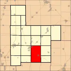
East Fork Township, Montgomery County, Illinois
East Fork Township (T8+N⅔T7N R3W) is located in Montgomery County, Illinois, United States. As of the 2010 census, its population was 2,566 and it contained 1,093 housing units.[2]
East Fork Township | |
|---|---|
 | |
.svg.png.webp) Location of Illinois in the United States | |
| Coordinates: 39°6′N 89°25′W | |
| Country | United States |
| State | Illinois |
| County | Montgomery |
| Settled | November 5, 1872 |
| Area | |
| • Total | 59.66 sq mi (154.5 km2) |
| • Land | 57.96 sq mi (150.1 km2) |
| • Water | 1.7 sq mi (4 km2) |
| Elevation | 617 ft (188 m) |
| Population (2010) | |
| • Estimate (2016)[1] | 2,467 |
| Time zone | UTC-6 (CST) |
| • Summer (DST) | UTC-5 (CDT) |
| FIPS code | 17-135-21761 |
Adjacent townships
- Irving Township (north)
- Witt Township (northeast)
- Fillmore Township (east)
- South Fillmore Township (east)
- Mulberry Grove Township, Bond County (southeast)
- La Grange Township, Bond County (south)
- Shoal Creek Township, Bond County (southwest)
- Grisham Township (west)
- Hillsboro Township (west)
- Butler Grove Township (northwest)
Geography
According to the 2010 census, the township has a total area of 59.66 square miles (154.5 km2), of which 57.96 square miles (150.1 km2) (or 97.15%) is land and 1.7 square miles (4.4 km2) (or 2.85%) is water.[2]
References
- "Population and Housing Unit Estimates". Retrieved June 9, 2017.
- "Population, Housing Units, Area, and Density: 2010 - County -- County Subdivision and Place -- 2010 Census Summary File 1". United States Census. Archived from the original on February 12, 2020. Retrieved May 28, 2013.
- "Census of Population and Housing". Census.gov. Retrieved June 4, 2016.
External links
Municipalities and communities of Montgomery County, Illinois, United States | ||
|---|---|---|
| Cities | Map of Illinois highlighting Montgomery County | |
| Villages | ||
| Townships | ||
| Unincorporated communities | ||
| Footnotes | ‡This populated place also has portions in an adjacent county or counties | |
This article is issued from Wikipedia. The text is licensed under Creative Commons - Attribution - Sharealike. Additional terms may apply for the media files.