Doniphan, Kansas
Doniphan is an unincorporated community in Doniphan County, Kansas, United States.[1]
Doniphan, Kansas | |
|---|---|
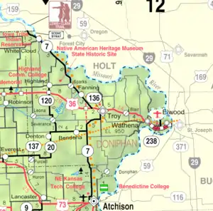 KDOT map of Doniphan County (legend) | |
 Doniphan  Doniphan | |
| Coordinates: 39°38′30″N 95°4′51″W[1] | |
| Country | United States |
| State | Kansas |
| County | Doniphan |
| Founded | 1854 |
| Platted | 1855 |
| Incorporated | 1869 |
| Named for | Alexander Doniphan |
| Elevation | 860 ft (260 m) |
| Time zone | UTC-6 (CST) |
| • Summer (DST) | UTC-5 (CDT) |
| Area code | 785 |
| FIPS code | 20-18275 |
| GNIS ID | 473282 [1] |
History
The company that founded the community was organized on November 11, 1854. Doniphan was incorporated in 1869.[2] The community was named for Alexander William Doniphan, a military leader in the Mexican–American War.[3]
A post office was opened in Doniphan on March 3, 1855, and remained in operation until it was discontinued on August 15, 1943.[4]
Demographics
Doniphan is part of the St. Joseph, MO–KS Metropolitan Statistical Area.
References
- "Doniphan, Kansas", Geographic Names Information System, United States Geological Survey, United States Department of the Interior
- Blackmar, Frank Wilson (1912). Kansas: A Cyclopedia of State History, Embracing Events, Institutions, Industries, Counties, Cities, Towns, Prominent Persons, Etc. Standard Publishing Company. pp. 528.
- History of the State of Kansas: Containing a Full Account of Its Growth from an Uninhabited Territory to a Wealthy and Important State. A. T. Andreas. 1883. p. 474.
- "Kansas Post Offices, 1828-1961 (archived)". Kansas Historical Society. Archived from the original on October 9, 2013. Retrieved June 8, 2014.
Further reading
External links
Municipalities and communities of Doniphan County, Kansas, United States | ||
|---|---|---|
| Cities | 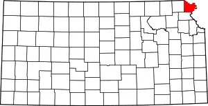 Map of Kansas highlighting Doniphan County | |
| Unincorporated communities | ||
| Ghost town | ||
| Indian reservation | ||
| Townships | ||
| Footnotes | †This community is designated a Census-Designated Place (CDP) by the United States Census Bureau. ‡This community also has portions in an adjacent county or counties. | |
This article is issued from Wikipedia. The text is licensed under Creative Commons - Attribution - Sharealike. Additional terms may apply for the media files.