D405 road
D405 branches off to the southwest from D8 near Jablanac towards Stinica ferry port - ferry access to Mišnjak, island of Rab (D105). The road is 4.8 km long.[1]
 | |
|---|---|
| Route information | |
| Length | 4.8 km (3.0 mi) |
| Major junctions | |
| From | |
| To | Stinica ferry port |
| Location | |
| Country | Croatia |
| Counties | Lika-Senj |
| Highway system | |

D405 road in Stinica
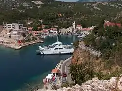
Jablanac, at the southern terminus of the D405 road
The road, as well as all other state roads in Croatia, is managed and maintained by Hrvatske ceste, state owned company.[2]
Traffic volume
Traffic is not regularly counted on the road, however, Hrvatske ceste report number of vehicles using Jablanac-Mišnjak ferry line, connecting D405 to the D105 state road.[3] Substantial variations between annual (AADT) and summer (ASDT) traffic volumes are attributed to the fact that the road connects to a number of summer resorts.
| D405 traffic volume | ||||
| Road | Counting site | AADT | ASDT | Notes |
| 337 Stinica-Mišnjak | 979 | 2,876 | Vehicles using Stinica-Mišnjak ferry line. | |
Road junctions and populated areas
| D405 junctions/populated areas | |
| Type | Slip roads/Notes |
| Jablanac | |
| Stinica ferry port - ferry access to Mišnjak, island of Rab[4] (D105). Southern terminus of the road. | |
Sources
- "Decision on categorization of public roads as state roads, county roads and local roads". Narodne novine (in Croatian). February 17, 2010.
- "Public Roads Act". Narodne novine (in Croatian). December 14, 2004.
- "Traffic counting on the roadways of Croatia in 2009 - digest" (PDF). Hrvatske ceste. May 1, 2010. Archived from the original (PDF) on July 21, 2011.
- "Jablanac-Mišnjak ferry line". May 11, 2010.
This article is issued from Wikipedia. The text is licensed under Creative Commons - Attribution - Sharealike. Additional terms may apply for the media files.