Cyclone Harvey
Severe Tropical Cyclone Harvey was a tropical cyclone that struck Queensland and the Northern Territory of Australia during the 2004–05 Australian region cyclone season. It had a minimum pressure of 967 mbar (hPa; 28.56 inHg)[1] and maximum wind gusts of 220 kilometres per hour (140 mph).[2]
| Category 3 severe tropical cyclone (Aus scale) | |
|---|---|
| Tropical storm (SSHWS) | |
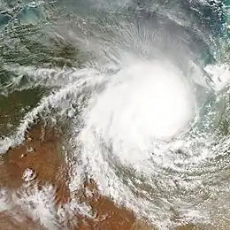
 Tropical Cyclone Harvey on 7 February 2005 | |
| Formed | 5 February 2005 |
| Dissipated | 7 February 2005 |
| Highest winds | 10-minute sustained: 120 km/h (75 mph) 1-minute sustained: 95 km/h (60 mph) Gusts: 220 km/h (140 mph) |
| Lowest pressure | 967 hPa (mbar); 28.56 inHg |
| Fatalities | None |
| Damage | $750,000 (2005 USD) |
| Areas affected | Northern Territory, Queensland |
| Part of the 2004–05 Australian region cyclone season | |
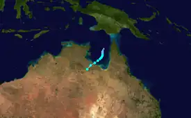
Meteorological history

Tropical storm (39–73 mph, 63–118 km/h)
Category 1 (74–95 mph, 119–153 km/h)
Category 2 (96–110 mph, 154–177 km/h)
Category 3 (111–129 mph, 178–208 km/h)
Category 4 (130–156 mph, 209–251 km/h)
Category 5 (≥157 mph, ≥252 km/h)
Unknown
A series of weak low pressure systems in the Gulf of Carpentaria and Timor Sea prompted the Bureau of Meteorology to go on Low Key Standby on 3 February 2005. While there was a moderate risk of tropical cyclone development, there were several weak lows, not a main well-defined low, and this led to High Key Standby being delayed until 4 February. On 5 February, the Brisbane Tropical Cyclone Warning Center (TCWC) issued an advice for municipalities along the southern side of the Gulf of Carpentaria as the Watch Phase was entered. On 6 February, Warning Phase commenced as Harvey strengthened to a Category 1 storm, and by 7 February, the cyclone had reached Category 3. The system then made landfall along the coast of the southern side of the gulf later that day.[3]
Preparations and impact
Warnings were issued along the coast between Mornington Island in Queensland and Port McArthur, Borroloola and Robinson River in the Northern Territory. Municipalities were warned to expect flooding and high tides.[4]
At Robinson River, flooding led to "severe road damage," which was estimated to be $1 million AUD ($750,000 USD in 2005). The river rose nearly 16 metres (52 ft), coming one metre away from the local power station. Downed trees and minor building damage was also reported. At Pungalina Station, strong winds and 60 mm (2.4 in) of rain were reported, and many trees were uprooted or broken.[5]
Aftermath
The Bureau of Meteorology retired the name Harvey after its usage.[6]
References
- "Tropical Cyclone HARVEY". Australian Government - Bureau of Meteorology. Archived from the original on 28 December 2010. Retrieved 3 September 2011.
- "Interim Report on tropical cyclone Harvey" (PDF). TROPICAL CYCLONE INFORMATION SERVICE. Queensland Government - Environmental Protection Agency. Archived from the original (PDF) on 14 March 2011. Retrieved 3 September 2011.
- "Tropical Cyclone Harvey". Previous Cyclones. Australian Government - Bureau of Meteorology. Retrieved 3 September 2011.
- "Harvey hits northern coast". The Age. 7 February 2005. Retrieved 3 September 2011.
- "SIGNIFICANT WEATHER - February 2005". Australian Government - Bureau of Meteorology. Retrieved 3 September 2011.
- "Tropical Cyclone Names". Australian Government - Bureau of Meteorology. Retrieved 11 August 2011.