Curtis Formation
The Curtis Formation is a geologic formation in Utah. It preserves fossils dating back to the Callovian age of the Jurassic period.

| Curtis Formation | |
|---|---|
| Stratigraphic range: | |
Curtis Formation type | |
| Type | Formation |
| Unit of | San Rafael Group |
| Underlies | Summerville Formation |
| Overlies | Entrada Sandstone |
| Lithology | |
| Primary | Sandstone |
| Other | Mudstone, limestone |
| Location | |
| Coordinates | 39.126665°N 110.447615°W |
| Region | Utah |
| Country | United States |
| Type section | |
| Named for | Curtis Point, Emery County, Utah |
| Named by | Gilluly and Reeside |
| Year defined | 1928 |
Description
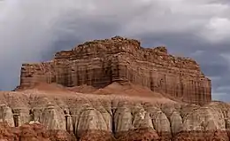
The Curtis Formation is composed of shallow marine sandstone, with thin beds of mudstone and minor limestone and gypsum. The sandstone is grayish-green in color and flat bedded or cross bedded. The presence of glauconite and marine invertebrate fossils indicates it was laid down in a shallow marine environment that became hypersaline towards the end of deposition. It represents a high stand of the Sundance Sea in the Callovian.[1]
History of investigation
The formation was first described by Gilluly and Reeside in 1928 and named for exposures in the northeast San Rafael Reef at Curtis Point (39.126665°N 110.447615°W). Pipiringos and Imlay reassigned the Curtis as a member of the Stump Formation in 1979,[2] but this was rejected by Peterson in 1988.[3]
Footnotes
- Lucas and Anderson 1992
- Pipiringos and Imlay 1979
- Peterson 1988
References
- Gilluly, James; Reeside, J.B., Jr. (1928). "Sedimentary rocks of the San Rafael Swell and some adjacent areas in eastern Utah". Shorter Contributions to General Geology, 1927: U.S. Geological Survey Professional Paper. 150-D: D61–D110.
{{cite journal}}: CS1 maint: multiple names: authors list (link) - Lucas, Spencer G.; Anderson, O.J. (November 1992). "The Middle Jurassic Summerville Formation, northern New Mexico" (PDF). New Mexico Geology. 14 (4). Retrieved 4 June 2020.
- Peterson, Fred (1988). "Stratigraphy and nomenclature of Middle and Upper Jurassic rocks, western Colorado Plateau, Utah and Arizona". Revisions to Stratigraphic Nomenclature of Jurassic and Cretaceous Rocks of the Colorado Plateau: U.S. Geological Survey Bulletin. 1633-B: B13-56.
- Pipiringos, G.N.; Imlay, R.W. (1979). "Lithology and subdivisions of the Jurassic Stump Formation in southeastern Idaho and adjoining areas". Unconformities, Correlations, and Nomenclature of Some Triassic and Jurassic Rocks, Western Interior United States: U.S. Geological Survey Professional Paper. 1035-C: C1–C25.
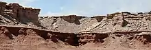
 Entrada (orange) and Curtis formations exposed in a road cut, Green River Cutoff Road. They are separated by the J3 unconformity.
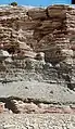
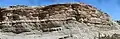 Lower and middle members of the Curtis Formation, Green River Cutoff Road, Emery County, Utah.