Curryville, Pennsylvania
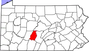
Curryville is an unincorporated community in Blair County, Pennsylvania, United States.[3] The community is located along Pennsylvania Route 866, 2.6 miles (4.2 km) south-southwest of Martinsburg. Curryville has a post office with ZIP code 16631.[4][5]
Curryville, Pennsylvania | |
|---|---|
Unincorporated community | |
 Curryville | |
| Coordinates: 40°16′33″N 78°20′18″W | |
| Country | United States |
| State | Pennsylvania |
| County | Blair |
| Area | |
| • Total | 0.15 sq mi (0.40 km2) |
| • Land | 0.15 sq mi (0.40 km2) |
| • Water | 0.00 sq mi (0.00 km2) |
| Elevation | 1,427 ft (435 m) |
| Population | |
| • Total | 111 |
| • Density | 725.49/sq mi (280.30/km2) |
| Time zone | UTC-5 (Eastern (EST)) |
| • Summer (DST) | UTC-4 (EDT) |
| ZIP code | 16631 |
| Area code | 814 |
| GNIS feature ID | 1172851[3] |
References
- "ArcGIS REST Services Directory". United States Census Bureau. Retrieved October 12, 2022.
- "Census Population API". United States Census Bureau. Retrieved October 12, 2022.
- "Curryville". Geographic Names Information System. United States Geological Survey, United States Department of the Interior.
- United States Postal Service. "USPS - Look Up a ZIP Code". Retrieved July 18, 2017.
- "Postmaster Finder - Post Offices by ZIP Code". United States Postal Service. Retrieved July 18, 2017.
- "Census of Population and Housing". Census.gov. Retrieved June 4, 2016.
This article is issued from Wikipedia. The text is licensed under Creative Commons - Attribution - Sharealike. Additional terms may apply for the media files.