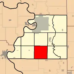
Crawford Township, Buchanan County, Missouri
Crawford Township is one of twelve townships in Buchanan County, Missouri, USA. As of the 2010 census, its population was 914.[3]
Crawford Township | |
|---|---|
 | |
| Coordinates: 39°35′01″N 094°50′59″W | |
| Country | United States |
| State | Missouri |
| County | Buchanan |
| Area | |
| • Total | 35.29 sq mi (91.4 km2) |
| • Land | 35.29 sq mi (91.4 km2) |
| • Water | 0 sq mi (0 km2) 0% |
| Elevation | 1,083 ft (330 m) |
| Population (2010) | |
| • Total | 914 |
| • Density | 27.8/sq mi (10.7/km2) |
| FIPS code | 29-17110[2] |
| GNIS feature ID | 0766339 |
Crawford Township was organized in the late 1830s, and named after William Crawford.[4]
Geography
Crawford Township covers an area of 35.29 square miles (91.4 km2) and contains no incorporated settlements. It contains seven cemeteries: Antioch, Judy, Richardson, Turner, Union, Williams and Willis.
Transportation
Crawford Township contains one airport or landing strip, Farris Strip Airport.
References
- "US Board on Geographic Names". United States Geological Survey. October 25, 2007. Retrieved January 31, 2008.
- "U.S. Census website". United States Census Bureau. Retrieved January 31, 2008.
- U.S. Census Bureau (September 2012). "2010 Census of Population and Housing, Population and Housing Unit Counts, Missouri" (PDF). U.S. Government Printing Office. Archived from the original (PDF) on October 21, 2016.
- "Buchanan County Place Names, 1928–1945 (archived)". The State Historical Society of Missouri. Archived from the original on June 24, 2016. Retrieved September 4, 2016.
{{cite web}}: CS1 maint: bot: original URL status unknown (link)
External links
Municipalities and communities of Buchanan County, Missouri, United States | ||
|---|---|---|
| Cities | 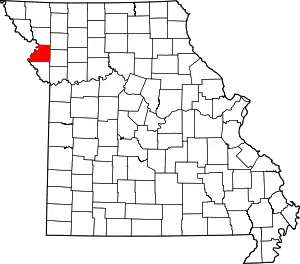 Map of Missouri highlighting Buchanan County | |
| Villages | ||
| Townships | ||
| CDP | ||
| Other communities | ||
| Footnotes | ‡This populated place also has portions in an adjacent county or counties | |
This article is issued from Wikipedia. The text is licensed under Creative Commons - Attribution - Sharealike. Additional terms may apply for the media files.