County of Granville
The County of Granville is one of the 49 counties of South Australia located in the Flinders Ranges region. It was proclaimed in 1876 by Governor Anthony Musgrave and was named for the Granville Leveson-Gower, the second Earl of Granville and the Secretary of State for the Colonies until a few years prior.[1]
| Granville South Australia | |||||||||||||||
|---|---|---|---|---|---|---|---|---|---|---|---|---|---|---|---|
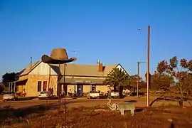
 Cradock Hotel in the Hundred of Wirreanda | |||||||||||||||
 Granville | |||||||||||||||
| Coordinates | 32.189°S 138.767°E | ||||||||||||||
| Established | 22 June 1876 | ||||||||||||||
| Area | 3,030 km2 (1,168 sq mi) | ||||||||||||||
| LGA(s) | District Council of Orroroo Carrieton Flinders Ranges Council | ||||||||||||||
| |||||||||||||||
Local government
Local government was first established in 1888 by the creation of the District Council of Carrieton, seated at the township of Carrieton on the county's southern border, and the District Council of Hawker, seated at the township of Hawker just north of the county's north-western extremity. The new councils were created by the passage of the District Councils Act 1887 on 5 January 1888. Carrieton council amalgamated with the southerly-adjacent District Council of Orroroo in 1997 to form the District Council of Orroroo Carrieton, which currently is the local government body in the county's southwest. Hawker amalgamated with the southerly adjacent District Council of Kanyaka-Quorn to form the Flinders Ranges Council, which currently is the local government body in the county's northwest.
Hundreds
The County of Granville comprises the following seven constituent hundreds:
- Hundred of Wirreanda, established 1877 (Cradock)
- Hundred of Yednalue, established 1877 (Cradock)
- Hundred of Uroonda, established 1877 (Cradock)
- Hundred of Eurilpa, established 1877 (Belton)
- Hundred of McCulloch, established 1886 (Belton)
- Hundred of Bendleby, established 1877 (Belton)
- Hundred of Yanyarrie, established 1877 (Yanyarrie, Carrieton)
References
- "Search for 'County of Granville, CNTY'". Government of South Australia. 5 June 2009. SA0027444. Retrieved 4 June 2018.
The Earl of Granville was twice the Secretary of State for the Colonies. Area 1168 square miles. Proclaimed on 22/6/1976.