County of Grande Prairie No. 1
The County of Grande Prairie No. 1 is a municipal district in northwestern Alberta, Canada in Census Division No. 19.
County of Grande Prairie No. 1 | |
|---|---|
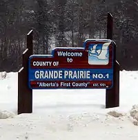 Welcome sign | |
|
Logo | |
| Nickname: Alberta's First County | |
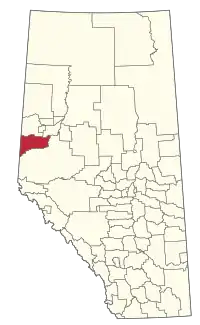 Location within Alberta | |
| Country | Canada |
| Province | Alberta |
| Region | Northern Alberta |
| Planning region | Upper Peace |
| Established | 1943 |
| Incorporated | 1951 |
| Government | |
| • Reeve | Leanne Beaupre |
| • Governing body | County of Grande Prairie No. 1 Council
|
| • Administrator | Joulia Whittleton |
| • Administrative office | Clairmont |
| Area (2021)[2] | |
| • Land | 5,790.59 km2 (2,235.76 sq mi) |
| Population (2021)[2] | |
| • Total | 23,769 |
| • Density | 4.1/km2 (11/sq mi) |
| Time zone | UTC−7 (MST) |
| • Summer (DST) | UTC−6 (MDT) |
| Website | countygp.ab.ca |
It is bounded on the south by the Wapiti River, on the east by the Smoky River and on the west by the province of British Columbia.
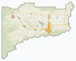
Geography
Communities and localities
|
The following urban municipalities are surrounded by the County of Grande Prairie No. 1.[3][4]
|
The following hamlets are located within the County of Grande Prairie No. 1.[4]
|
The following localities are located within the County of Grande Prairie No. 1.[5]
- Localities
|
|
|
|
Horse Lakes 152B is an Indian reserves located within the County of Grande Prairie No. 1.
Demographics
| Year | Pop. | ±% |
|---|---|---|
| 1951 | 10,126 | — |
| 1956 | 8,899 | −12.1% |
| 1961 | 8,803 | −1.1% |
| 1966 | 8,697 | −1.2% |
| 1971 | 8,496 | −2.3% |
| 1976 | 9,147 | +7.7% |
| 1981 | 12,078 | +32.0% |
| 1986 | 12,075 | −0.0% |
| 1991 | 12,314 | +2.0% |
| 1996 | 13,537 | +9.9% |
| 2001 | 15,638 | +15.5% |
| 2006 | 17,970 | +14.9% |
| 2011 | 19,724 | +9.8% |
| 2016 | 22,303 | +13.1% |
| Source: Statistics Canada [6][7][8][9][10][11][12][13] | ||
In the 2021 Census of Population conducted by Statistics Canada, the County of Grande Prairie No. 1 had a population of 23,769 living in 8,354 of its 9,075 total private dwellings, a change of 5.6% from its 2016 population of 22,502. With a land area of 5,790.59 km2 (2,235.76 sq mi), it had a population density of 4.1/km2 (10.6/sq mi) in 2021.[2]
In the 2016 Census of Population conducted by Statistics Canada, the County of Grande Prairie No. 1 had a population of 22,303 living in 7,684 of its 8,291 total private dwellings, a 13.1% change from its 2011 population of 19,724. With a land area of 5,802.21 km2 (2,240.25 sq mi), it had a population density of 3.8/km2 (10.0/sq mi) in 2016.[13]
The County of Grande Prairie No. 1 conducted a municipal census in 2012, which resulted in an estimated population of 21,157,[14] a 17.6% increase over its 2006 municipal census population of 17,989.[15]
References
- "Municipal Officials Search". Alberta Municipal Affairs. May 9, 2019. Retrieved October 1, 2021.
- "Population and dwelling counts: Canada, provinces and territories, and census subdivisions (municipalities)". Statistics Canada. February 9, 2022. Retrieved February 9, 2022.
- "Grande Prairie, City (Census Subdivision), Alberta". Statistics Canada. June 20, 2012. Retrieved August 13, 2012.
- "Specialized and Rural Municipalities and Their Communities" (PDF). Alberta Municipal Affairs. January 12, 2022. Retrieved January 21, 2022.
- "Standard Geographical Classification (SGC) 2006, Economic Regions: 4819006 - Grande Prairie County No. 1, geographical codes and localities, 2006". Statistics Canada. March 5, 2010. Archived from the original on May 25, 2013. Retrieved August 11, 2012.
- "Table 6: Population by sex, for census subdivisions, 1956 and 1951". Census of Canada, 1956. Vol. I: Population. Ottawa: Dominion Bureau of Statistics. 1958.
- "Table 9: Population by census subdivisions, 1966 by sex, and 1961". 1966 Census of Canada. Western Provinces. Vol. Population: Divisions and Subdivisions. Ottawa: Dominion Bureau of Statistics. 1967.
- "Table 3: Population for census divisions and subdivisions, 1971 and 1976". 1976 Census of Canada. Census Divisions and Subdivisions, Western Provinces and the Territories. Vol. Population: Geographic Distributions. Ottawa: Statistics Canada. 1977.
- "Table 2: Census Subdivisions in Alphabetical Order, Showing Population Rank, Canada, 1981". 1981 Census of Canada. Vol. Census subdivisions in decreasing population order. Ottawa: Statistics Canada. 1982. ISBN 0-660-51563-6.
- "Table 2: Population and Dwelling Counts, for Census Divisions and Census Subdivisions, 1986 and 1991 – 100% Data". 91 Census. Vol. Population and Dwelling Counts – Census Divisions and Census Subdivisions. Ottawa: Statistics Canada. 1992. pp. 100–108. ISBN 0-660-57115-3.
- "Population and Dwelling Counts, for Canada, Provinces and Territories, and Census Divisions, 2001 and 1996 Censuses – 100% Data (Alberta)". Statistics Canada. Retrieved May 25, 2019.
- "Population and dwelling counts, for Canada, provinces and territories, and census subdivisions (municipalities), 2006 and 2001 censuses – 100% data (Alberta)". Statistics Canada. January 6, 2010. Retrieved May 25, 2019.
- "Population and dwelling counts, for Canada, provinces and territories, and census subdivisions (municipalities), 2016 and 2011 censuses – 100% data (Alberta)". Statistics Canada. February 8, 2017. Retrieved February 8, 2017.
- "County Releases Population Estimates" (PDF). County of Grande Prairie No. 1. November 5, 2012. Retrieved April 10, 2013.
- Alberta Municipal Affairs (September 15, 2009). "Alberta 2009 Official Population List" (PDF). Retrieved September 12, 2010.
External links
Places adjacent to County of Grande Prairie No. 1 | |
|---|---|