Clough
%252C_October_2009.JPG.webp)
Clough, October 2009
Clough (/ˈklɒx/ KLOKH;[1] from Irish: an Chloch, meaning 'the stone') is a village and townland in County Down, Northern Ireland. It sits about 3 miles from Dundrum on the A2 between Newcastle and Belfast. The A2 continues via Downpatrick and the coast via Strangford and the Portaferry - Strangford Ferry to Portaferry to Belfast, whilst most road traffic heads along from Clough along the A24 via Carryduff to Belfast. It had a population of 255 people in the 2001 Census. Clough is situated within the Newry, Mourne and Down area.
Places of interest
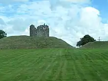
Clough Castle
- Clough Castle, an excellent example of an Anglo-Norman motte-and-bailey castle with stone tower.
Etymology
A map of 1634 marked the village as Machaeracate and the castle is Cloch Mhachaire Cat "Stone castle of the plain of the cat". This comes from a local legend of the chase of magic cat.[2]
References
- Wells, John C. (2008). Longman Pronunciation Dictionary (3rd ed.). Longman. ISBN 978-1-4058-8118-0.
- Muhr, Kay (2005). "An Elizabethan map of north-east Down". Lecale Review. 3: 11.
External links
Wikimedia Commons has media related to Clough, County Down.

This article is issued from Wikipedia. The text is licensed under Creative Commons - Attribution - Sharealike. Additional terms may apply for the media files.