Clarita, Oklahoma
Clarita is a small unincorporated community in Coal County, Oklahoma, United States.[2] The post office was established January 19, 1910.
Clarita, Oklahoma | |
|---|---|
 Clarita Location within the state of Oklahoma  Clarita Clarita (the United States) | |
| Coordinates: 34°28′57″N 96°26′12″W | |
| Country | United States |
| State | Oklahoma |
| County | Coal |
| Area | |
| • Total | 7.91 sq mi (20.48 km2) |
| • Land | 7.90 sq mi (20.47 km2) |
| • Water | 0.00 sq mi (0.01 km2) |
| Elevation | 692 ft (211 m) |
| Population (2020) | |
| • Total | 135 |
| • Density | 17.08/sq mi (6.60/km2) |
| Time zone | UTC-6 (Central (CST)) |
| • Summer (DST) | UTC-5 (CDT) |
| FIPS code | 40-14750 |
| GNIS feature ID | 2629912[2] |
Clarita's school district, Olney Public School District, is one of the smallest public school districts in the state of Oklahoma. For the most recent data available, for a combined district, K-12, Olney finished between Boley (51) and Sweetwater (60), with 58 students. Olney School is now closed although the reunion is still held at the lunch room.[3]
The Census Bureau defined a census-designated place (CDP) for Clarita in 2015; the 2010 population within the 2015 CDP boundary is 171 and contains 70 housing units.
References
- "ArcGIS REST Services Directory". United States Census Bureau. Retrieved September 20, 2022.
- U.S. Geological Survey Geographic Names Information System: Clarita, Oklahoma
- School District Database at the Oklahoma State Department of Education (OSDE) Archived 2007-08-02 at the Wayback Machine
- "Census of Population and Housing". Census.gov. Retrieved June 4, 2016.
External links
Municipalities and communities of Coal County, Oklahoma, United States | ||
|---|---|---|
| Cities | 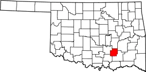 Coal County map | |
| Towns | ||
| CDPs | ||
| Other communities | ||
| Indian reservations | ||
| Footnotes | ‡This populated place also has portions in an adjacent county or counties | |
This article is issued from Wikipedia. The text is licensed under Creative Commons - Attribution - Sharealike. Additional terms may apply for the media files.