Chicopee, Kansas
Chicopee is an unincorporated community in Crawford County, Kansas, United States.[1] As of the 2020 census, the population of the community and nearby areas was 422.[2]
Chicopee, Kansas | |
|---|---|
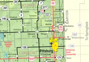 KDOT map of Crawford County (legend) | |
 Chicopee  Chicopee | |
| Coordinates: 37°26′25″N 94°49′42″W[1] | |
| Country | United States |
| State | Kansas |
| County | Crawford |
| Area | |
| • Total | 3.2 sq mi (8.3 km2) |
| • Land | 3.2 sq mi (8.2 km2) |
| • Water | 0.04 sq mi (0.1 km2) |
| Elevation | 919 ft (280 m) |
| Population | |
| • Total | 422 |
| • Density | 130/sq mi (51/km2) |
| Time zone | UTC-6 (CST) |
| • Summer (DST) | UTC-5 (CDT) |
| Area code | 620 |
| FIPS code | 20-13100 |
| GNIS ID | 2630052[1] |
History
Chicopee was a coal mining community.
The post office opened June 10, 1889, closed September 30, 1892, reopened October 8, 1892, and reclosed March 30, 1918.
Chicopee was the home of the defunct Idlehour amusement park.[3]
Geography
Chicopee lies at the intersection of the county roads known as South 200th Street & East 530th Avenue, 4 miles (6 km) by road southwest of downtown Pittsburg. The northwest corner of the town borders on the grounds of the Crestwood Country Club. The Crestwood golf course opened in 1958.[4]
Demographics
| Census | Pop. | Note | %± |
|---|---|---|---|
| 2010 | 408 | — | |
| 2020 | 422 | 3.4% | |
| U.S. Decennial Census | |||
For statistical purposes, the United States Census Bureau has defined Chicopee as a census-designated place (CDP).
References
- U.S. Geological Survey Geographic Names Information System: Chicopee, Kansas
- "Profile of Chicopee, Kansas (CDP) in 2020". United States Census Bureau. Archived from the original on November 18, 2021. Retrieved November 17, 2021.
- "Defunct Amusement Parks of Kansas". defunctparks.com. Archived from the original on October 11, 2014.
- Crestwood Gold Course
Further reading
External links
Municipalities and communities of Crawford County, Kansas, United States | ||
|---|---|---|
| Cities |  Map of Kansas highlighting Crawford County | |
| Unincorporated communities | ||
| Townships | ||
| Footnotes | †This community is designated a Census-Designated Place (CDP) by the United States Census Bureau. ‡This community also has portions in an adjacent county or counties. | |