Cherokee Township, Cherokee County, Kansas
Cherokee Township is a township in Cherokee County, Kansas, USA. As of the 2000 census, its population was 336.
Cherokee Township | |
|---|---|
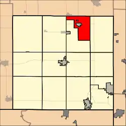 Location in Cherokee County | |
| Coordinates: 37°17′47″N 094°46′21″W | |
| Country | United States |
| State | Kansas |
| County | Cherokee |
| Area | |
| • Total | 22.2 sq mi (57.5 km2) |
| • Land | 22.18 sq mi (57.46 km2) |
| • Water | 0.02 sq mi (0.05 km2) 0.09% |
| Elevation | 928 ft (283 m) |
| Population (2000) | |
| • Total | 336 |
| • Density | 15.1/sq mi (5.8/km2) |
| GNIS feature ID | 0469617 |
Geography
Cherokee Township covers an area of 22.2 square miles (57 km2) surrounding the incorporated settlement of Weir. According to the USGS, it contains three cemeteries: Council Corners, New Pleasant View and Saint Anthony.
External links
Municipalities and communities of Cherokee County, Kansas, United States | ||
|---|---|---|
| Cities | 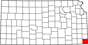 Map of Kansas highlighting Cherokee County | |
| Unincorporated communities | ||
| Ghost towns | ||
| Townships | ||
| Footnotes | †This community is designated a Census-Designated Place (CDP) by the United States Census Bureau. ‡This community also has portions in an adjacent county or counties. | |
This article is issued from Wikipedia. The text is licensed under Creative Commons - Attribution - Sharealike. Additional terms may apply for the media files.