Cherokee, Victoria
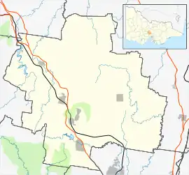
Cherokee /ˈtʃɛrəki/ is a locality situated in the Macedon Ranges Shire, in Victoria, Australia 73 kilometres (45 mi) north of the state capital, Melbourne.
| Cherokee Victoria | |||||||||||||||
|---|---|---|---|---|---|---|---|---|---|---|---|---|---|---|---|
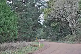
 Gap Road at Cherokee | |||||||||||||||
 Cherokee | |||||||||||||||
| Coordinates | 37°23′S 144°38′E | ||||||||||||||
| Population | 68 (SAL 2021)[1] | ||||||||||||||
| Established | 1880 | ||||||||||||||
| Postcode(s) | 3434 | ||||||||||||||
| Elevation | 730 m (2,395 ft) | ||||||||||||||
| LGA(s) | Shire of Macedon Ranges | ||||||||||||||
| State electorate(s) | Macedon | ||||||||||||||
| Federal division(s) | McEwen | ||||||||||||||
| |||||||||||||||
The settlement as it appears today was created by land subdivision around 1880–1881, although the area was occupied by Europeans before this date. Timber mills and a school were operating by 1865, possibly earlier, in response to the demand for timber created by the Victorian gold rush.[2]
Cherokee Post Office opened on 1 July 1927 and closed in 1955.[3]
References
Wikimedia Commons has media related to Cherokee, Victoria.
- Australian Bureau of Statistics (28 June 2022). "Cherokee (Suburb and Locality)". Australian Census 2021 QuickStats. Retrieved 28 June 2022.
- Smith, Gavin (1994). All Wild and Lonely Bush. Romsey: Shire of Romsey Book Committee. pp. 22 and 37. ISBN 0-646-23834-5.
- Phoenix Auctions History. "Post Office List". Retrieved 5 April 2021.
This article is issued from Wikipedia. The text is licensed under Creative Commons - Attribution - Sharealike. Additional terms may apply for the media files.