Chatkal
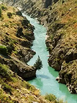
The Chatkal (Russian: Чаткал) is a river of Jalal-Abad Region, Kyrgyzstan and Tashkent Region in Uzbekistan. It is the left source river of the Chirchiq in the Syr Darya basin. In its upper course it is called Karakulja.[1]
| Chatkal | |
|---|---|
 | |
| Native name | Чаткал (Russian) |
| Location | |
| Country | Kyrgyzstan, Uzbekistan |
| Physical characteristics | |
| Mouth | Chirchiq |
• location | Lake Charvak |
• coordinates | 41°35′08″N 70°05′57″E |
| Length | 223 km (139 mi) |
| Basin size | 7,110 km2 (2,750 sq mi) |
| Basin features | |
| Progression | Chirchiq→ Syr Darya→ North Aral Sea |
| Tributaries | |
| • left | Tüz-Ashuu, Ters, Oqbuloq |
| • right | Chandalash |
The length of the river is 223 kilometres (139 mi), with a basin area of 7,110 square kilometres (2,750 sq mi).[2] It originates at the point where Chatkal Range adjoins Talas Ala-Too Range. Its largest tributaries are the Aksuu, Kokuybel, Avletim, Ters and Nayza (Oqbuloq) from the left, and the Karakysmak, Beshterek, Chandalash and Köksuu from the right.[1]
The average rate of water flow near the mouth is 122 cubic metres per second (4,300 cu ft/s), with a maximum 920 cubic metres per second (32,000 cu ft/s).
References
- "Чаткал" [Chatkal] (PDF). Кыргызстандын Географиясы [Geography of Kyrgyzstan] (in Kyrgyz). Bishkek. 2004. p. 210.
{{cite encyclopedia}}: CS1 maint: location missing publisher (link) - Чаткал, Great Soviet Encyclopedia
External links
| Rivers | |
|---|---|
This article is issued from Wikipedia. The text is licensed under Creative Commons - Attribution - Sharealike. Additional terms may apply for the media files.