Charlotte Amalie Historic District
The Charlotte Amalie Historic District in Charlotte Amalie in Saint Thomas, U.S. Virgin Islands is a 165.3 acres (0.669 km2) historic district which was listed on the National Register of Historic Places in 1976.[1]
Charlotte Amalie Historic District | |
 | |
 | |
| Location | Roughly bounded by Nytvaer, Berg and Government Hills, Bjebre Gade and St. Thomas Harbor, Charlotte Amalie, Virgin Islands |
|---|---|
| Coordinates | 18.345°N 64.931944°W |
| Area | 165.3 acres (0.669 km2) |
| Architectural style | Greek Revival |
| NRHP reference No. | 76001860[1] |
| Added to NRHP | July 19, 1976 |
The district then included 574 contributing buildings, three contributing structures, and a contributing object.[1] It included the entire Charlotte Amalie National Historic Site (also known as St. Thomas National Historic Site, which was a National Historic Site from December 24, 1960, until February 5, 1975, when it was disbanded and transferred to Virgin Islands, to be administered as a territorial park). It also included the entire local Charlotte Amalie Historic and Architectural Control District.[2]
European construction in the district began with the building of Fort Christian in c.1666; the town of Charlotte Amalie was platted in 1681.[2]
Notable properties include:
- Fort Christian (c.1666-1680), modified in 1874
- Legislative Building (1874), built as barracks for the Danish police force, in 1976 this was home for the Virgin Islands Senate.
- Emancipation Park, honoring 1848 emancipation of slaves

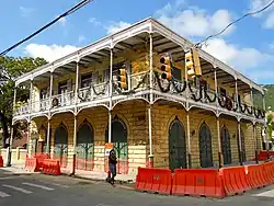
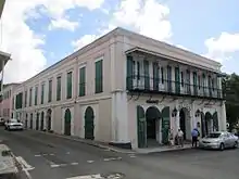
- Commercial Hotel and Coffee House (1839–40), also formerly known as the Grand Hotel, 44 Norre Gade. Greek Reivival with an arcaded first floor.[2]
References
- "National Register Information System". National Register of Historic Places. National Park Service. July 9, 2010.
- Russell Wright (May 20, 1976). "National Register of Historic Places Inventory/Nomination: Charlotte Amalie Historic District". National Park Service. Retrieved May 24, 2017. With 28 photos from 1976.
.svg.png.webp)