Central Bangka Regency
Central Bangka Regency is a regency (kabupaten) of the Bangka Belitung Islands Province, Indonesia. It covers an area of 2,155.77 km2[2] and had a population of 161,075 at the 2010 Census,[3] rising to 198,946 at the 2020 Census;[4] the official estimate as at mid 2022 was 205,510.[1] The town of Koba is its regency seat.
Central Bangka Regency
Kabupaten Bangka Tengah | |
|---|---|
 Coat of arms | |
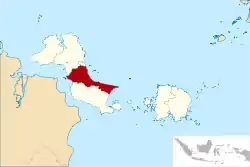 Location within Bangka Belitung Islands | |
| Coordinates: 2°25′S 106°14′E | |
| Country | Indonesia |
| Province | Bangka Belitung Islands |
| Regency seat | Koba |
| Government | |
| • Regent | Yulianto Satin (Acting) |
| • Deputy Regent | Vacant |
| Area | |
| • Total | 2,269.03 km2 (876.08 sq mi) |
| Population (mid 2022 estimate)[1] | |
| • Total | 205,510 |
| • Density | 91/km2 (230/sq mi) |
| Time zone | UTC+7 (IWST) |
| Area code | (+62) 718 |
| Website | bangkatengahkab.go.id |
Administrative Districts
The Regency is divided into six districts (kecamatan), tabulated below with their areas and their populations at the 2010 Census[3] and 2020 Census.[4] The table also includes the numbers of administrative villages (rural desa and urban kelurahan) and offshore islands in each district, and its postal code.
| Name of District (kecamatan) | Area in km2 | Pop'n Census 2010 | Pop'n Census 2020 | No. of villages | Post code |
|---|---|---|---|---|---|
| Koba (a) | 390.54 | 34,808 | 42,929 | 11 | 33681 |
| Lubuk Besar (b) | 546.10 | 22,712 | 31,153 | 9 | 33682 |
| Pangkalan Baru (b) | 109.45 | 37,473 | 46,027 | 12 | 33684 |
| Namang | 204.04 | 13,912 | 16,837 | 8 | 33683 |
| Sungai Selan (c) | 789.83 | 30,048 | 36,073 | 13 | 33675 |
| Simpang Katis | 229.07 | 22,275 | 25,927 | 10 | 33674 |
| Totals | 2,269.03 | 161,075 | 198,946 | 63 |
Notes: (a) includes 8 offshore islands. (b) includes 3 offshore islands. (c) includes 6 offshore islands.
References
- Badan Pusat Statistik, Jakarta, 2023, Kabupaten Bangka Tengah Dalam Angka 2023 (Katalog-BPS 1102001.1904)
- There is a discrepancy with the figures reported by national office of BPS and that reported by the local BPS, which gives 2,269.03 km2 as shown in the table of districts.
- Biro Pusat Statistik, Jakarta, 2011.
- Badan Pusat Statistik, Jakarta, 2021.
External links
Wikimedia Commons has media related to Central Bangka Regency.
Regencies and cities of the Bangka Belitung Islands | ||
|---|---|---|
Capital: Pangkalpinang | ||
| Regencies | ||
| Cities | ||
This article is issued from Wikipedia. The text is licensed under Creative Commons - Attribution - Sharealike. Additional terms may apply for the media files.