Carondelet Park
Carondelet Park, established in 1875, is the third largest park in the city of St. Louis, Missouri. The park contains nearly 180 acres (0.73 km2)[1] and is located in the southeastern portion of the city, just west of Interstate 55, and is accessible at the Loughborough Avenue exit. Loughborough Avenue is the park's southern boundary; its northern boundary is Holly Hills Boulevard. The park takes its name from Carondelet, St. Louis.[2][3] The Carondelet, Holly Hills, Boulevard Heights, and Bevo Mill neighborhoods surround the park, and the park is a focal point for the community.
| Carondelet Park | |
|---|---|
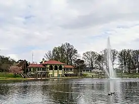
 Carondelet Park lake and boathouse in spring. | |
| Type | Urban park |
| Location | St. Louis, Missouri, United States |
| Coordinates | 38.5625°N 90.2646°W |
| Area | 180 acres (73 ha) |
| Created | 1875 |
| Operated by | St. Louis Department of Parks, Recreation, and Forestry |
| Public transit access | |
| Website | http://stlouis-mo.gov |
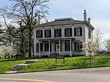
Among other features, the park contains two lakes that are stocked for fishing, tennis courts, softball, baseball, and soccer fields. The park also has playgrounds, a recycling center (with mulch and compost), picnic areas, and a 1.6-mile (2.6 km) bicycle path. The Alexander Lyle house, a historic home dated around 1840, is located on the property.
A community recreation center is on the eastern edge of the park adjacent to I-55.
According to resident historian Steven Strohmeyer, the park is home to the White Wall, a large concrete wall, white in color, where a local underground fight club met in the early 1980s.

References
- Wright, John Aaron; Wright, Sylvia A. (2008). Carondelet. Arcadia Publishing. ISBN 978-0-7385-5206-4.
- "St. Louis County Place Names, 1928–1945". The State Historical Society of Missouri. Archived from the original on June 24, 2016. Retrieved December 22, 2016.
- Thomas, Joan M. (2003-11-01). St. Louis: 1875-1940. Arcadia Publishing. ISBN 978-1-4396-3125-6.