Caramoan National Park
The Caramoan National Park is a 347-hectare (860-acre) national park and protected area in Camarines Sur, Philippines. It was established in 1938.[2] The park has caves, limestone formations, white sandy beaches, an islet lake and a subterranean river, make it popular with tourists. It is accessible by public transport from the municipality of Caramoan, and local people have established trails in the park for visitors.
| Caramoan National Park | |
|---|---|
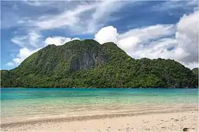 Pitogo Island off Caramoan Peninsula | |
| Location | Camarines Sur, Bicol Region, Philippines |
| Coordinates | 13.800°N 123.882°E[1] |
| Area | 347 ha (860 acres) |
| Established | 1938 |
Geography
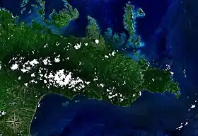
Caramoan Peninsula seen from space
The national park is located in the Caramoan Peninsula, a hilly peninsula in north-east Camarines Sur, Bicol Region, Philippines with deep gorges and a rough, rocky terrain. It is also an Important Bird Area with habitat for the green racket-tail (Prioniturus luconensis).[3]
References
- "Caramoan National Park". protectedplanet.net.
- "Proclamation No. 291, s. 1938". Official Gazette of the Republic of the Philippines. Retrieved December 31, 2012.
- "Caramoan peninsula". BirdLife International. Retrieved December 31, 2012.
This article is issued from Wikipedia. The text is licensed under Creative Commons - Attribution - Sharealike. Additional terms may apply for the media files.