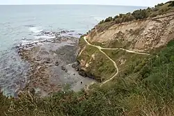
Cape Wanbrow
Cape Wanbrow is a rocky headland overlooking Oamaru Harbour, New Zealand. Although it has been a commercial forestry area for a number of decades, the cape is now primarily a Council controlled reserve, and is gradually being replanted with native trees and shrubs.[3] It has a network of walking tracks and mountain bike tracks, and is popular with the public.
Cape Wanbrow | |
|---|---|
 Cliff adjacent to Cape Wanbrow | |
| Offshore water bodies | South Pacific Ocean |
| Age | |
| Formed by | Erosion and volcanism |
| Geology | basaltic tephra deposits, tholeiitic pillow lavas, limestone,mudstone and siltstone[1] |
| Highest elevation | 133 m (436 ft)[2] |
Cape Wanbrow was an important lookout point during the Second World War and hosts a gun emplacement and remains of the original magazine which served the fortified gun.[4] Below the cape on its north side is a protected area which is home to a blue penguin colony, and rare yellow eyed penguins are to the south of the cape.[5] New Zealand fur seals and occasionally elephant seals are found resting on the rocks.[6]
The geology of the rock making up the cape is complex as layered within the sedimentary rocks are no less than 6 Surtseyan volcanoes of the monogenetic Waiareka-Deborah volcanic field.[1]
References
- Moorhouse, BL; White, JD; Scott, JM (2015). "Cape Wanbrow: A stack of Surtseyan-style volcanoes built over millions of years in the Waiareka–Deborah volcanic field, New Zealand". Journal of Volcanology and Geothermal Research. 298: 27–46. doi:10.1016/j.jvolgeores.2015.03.019.
- "Cape Wanbrow revegetation project". www.waitaki.govt.nz. 21 December 2016. Archived from the original on 25 April 2017. Retrieved 22 May 2021.
- "Cape Wanbrow to reopen soon". Otago Daily Times Online News. 12 April 2014. Retrieved 22 May 2021.
- "Innovative ideas for Cape Wanbrow". Oamaru Mail. 26 June 2014. Archived from the original on 14 July 2014. Retrieved 22 May 2021.
- Laing, Steuart (16 September 2015). "Seals, seaweed and sightseeing on Oamaru's coastline". Stuff. Retrieved 22 May 2021.