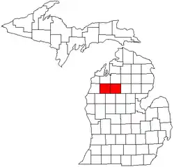
Cadillac micropolitan area
The Cadillac micropolitan area is a micropolitan statistical area (μSA) defined by the United States Census Bureau as an area encompassing two counties (Missaukee and Wexford) in the U.S. state of Michigan. The population of the μSA was 48,725 at the 2020 census (33,673 in Wexford County and 15,052 in Missaukee County).[1][2]
Cadillac micropolitan area | |
|---|---|
 Michigan counties included in the Cadillac μSA | |
| Coordinates: 44°20′21″N 85°20′20″W | |
| Country | United States |
| State | Michigan |
| Counties | Missaukee and Wexford |
| Principal city | Cadillac |
| Area | |
| • Total | 1,149.46 sq mi (2,977.09 km2) |
| • Land | 1,129.90 sq mi (2,926.43 km2) |
| • Water | 19.56 sq mi (50.66 km2) |
| Population (2020) | |
| • Total | 48,725 (219th) |
| • Density | 43.12/sq mi (16.65/km2) |
| Time zone | UTC−5 (Eastern (EST)) |
| • Summer (DST) | UTC−4 (EDT) |
| Area code | 231 |
The principal city of the μSA is Cadillac, which had a population of 10,371 at the 2020 census.
Counties
Incorporated municipalities
.png.webp)
U.S. Census data map showing local municipal boundaries within Wexford County (left) and Missaukee County (right). Shaded areas represent incorporated cities.
Townships
Charter township
Civil townships
- Aetna Township
- Antioch Township
- Bloomfield Township
- Boon Township
- Butterfield Township
- Caldwell Township
- Cedar Creek Township
- Cherry Grove Township
- Clam Lake Township
- Clam Union Township
- Colfax Township
- Enterprise Township
- Forest Township
- Greenwood Township
- Hanover Township
- Henderson Township
- Holland Township
- Lake Township
- Liberty Township
- Norwich Township
- Pioneer Township
- Reeder Township
- Richland Township
- Riverside Township
- Selma Township
- Slagle Township
- South Branch Township
- Springville Township
- West Branch Township
- Wexford Township
Unincorporated communities
Other unincorporated communities
- Arlene
- Axin
- Bagnall
- Baxter
- Benson
- Butterfield
- Cutcheon
- Dinca
- Dolph
- Garletts Corner
- Gilbert
- Glengary
- Harlan
- Hobart
- Hoxeyville
- Keelans Corner
- Lucas
- Meauwataka
- Merritt
- Millersville
- Missaukee Junction
- Moddersville
- Moorestown
- Morey
- Pioneer
- Prosper
- Sherman
- Star City
- Stittsville
- Stoney Corner
- Vogel Center
- Walton
- Wexford Corner
- Yuma
See also
References
- "State & County QuickFacts: Wexford County". United States Census Bureau. Retrieved September 15, 2021.
- "State & County QuickFacts: Missaukee County". United States Census Bureau. Retrieved September 15, 2021.
This article is issued from Wikipedia. The text is licensed under Creative Commons - Attribution - Sharealike. Additional terms may apply for the media files.
.jpg.webp)
.jpg.webp)

