Brooks, Montana
Brooks is an unincorporated community and census-designated place (CDP) in Fergus County, Montana, United States. It is in the west-central part of the county, on the south side of Montana Highway 81, 11 miles (18 km) north of Lewistown and 27 miles (43 km) southeast of Denton.
Brooks, Montana | |
|---|---|
 Brooks  Brooks | |
| Coordinates: 47°12′20″N 109°25′18″W | |
| Country | United States |
| State | Montana |
| County | Fergus |
| Area | |
| • Total | 0.09 sq mi (0.23 km2) |
| • Land | 0.09 sq mi (0.23 km2) |
| • Water | 0.00 sq mi (0.00 km2) |
| Elevation | 3,963 ft (1,208 m) |
| Population (2020) | |
| • Total | 18 |
| • Density | 206.90/sq mi (79.80/km2) |
| Time zone | UTC-7 (Mountain (MST)) |
| • Summer (DST) | UTC-6 (MDT) |
| ZIP Code | 59457 (Lewistown) |
| Area code | 406 |
| FIPS code | 30-10150 |
| GNIS feature ID | 2804284[2] |
The community was first listed as a CDP prior to the 2020 census.[2]
References
- "ArcGIS REST Services Directory". United States Census Bureau. Retrieved September 5, 2022.
- "Brooks Census Designated Place". Geographic Names Information System. United States Geological Survey, United States Department of the Interior.
- "Census of Population and Housing". Census.gov. Retrieved June 4, 2016.
Municipalities and communities of Fergus County, Montana, United States | ||
|---|---|---|
| City | 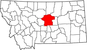 Fergus County map | |
| Towns | ||
| CDPs | ||
| Other communities | ||
| Ghost town | ||
| Indian reservation | ||
| Footnotes | ‡This populated place also has portions in an adjacent county or counties | |
This article is issued from Wikipedia. The text is licensed under Creative Commons - Attribution - Sharealike. Additional terms may apply for the media files.