Broadbeach Waters, Queensland
Broadbeach Waters is a suburb in the City of Gold Coast, Queensland, Australia.[2] In the 2021 census, Broadbeach Waters had a population of 8,164 people.[3]
| Broadbeach Waters Gold Coast, Queensland | |||||||||||||||
|---|---|---|---|---|---|---|---|---|---|---|---|---|---|---|---|
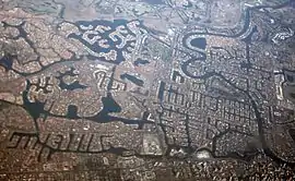
 Residential canals on the Gold Coast, including Broadbeach Waters | |||||||||||||||
 Broadbeach Waters | |||||||||||||||
| Coordinates | 28.0263°S 153.4172°E | ||||||||||||||
| Population | 8,164 (SAL 2021)[1] | ||||||||||||||
| Postcode(s) | 4218 | ||||||||||||||
| Elevation | 4 m (13 ft) | ||||||||||||||
| Area | 5.3 km2 (2.0 sq mi) | ||||||||||||||
| Time zone | AEST (UTC+10:00) | ||||||||||||||
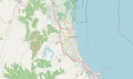
| Location |
| ||||||||||||||
| LGA(s) | Gold Coast City | ||||||||||||||
| State electorate(s) | Surfers Paradise | ||||||||||||||
| Federal division(s) | Moncrieff | ||||||||||||||
| |||||||||||||||
Geography

The northern boundary of Broadbeach Waters follows the Nerang River. The suburb is almost completed residential with most properties adjacent to or very close to man-made canals. Pacific Fair Shopping Centre is located in the south east corner of the suburb.
There are a number of neighborhoods in the suburb:
- Cypress Gardens (28.0283°S 153.3974°E)[4]
- Florida Gardens (28.0202°S 153.4247°E)[5]
- Miami Keys (28.0344°S 153.4205°E)[6]
- Moana (28.0253°S 153.4141°E)[7]
- Rialto (28.0233°S 153.4094°E)[8]
- Rio Vista (28.02°S 153.4161°E)[9]
History
In the 2016 census, Broadbeach Waters recorded a population of 7,779 people.[10] The median age of the Broadbeach Waters population was 43 years, 5 years above the national median of 38. 65.2% of people were born in Australia. The most common countries of birth were New Zealand 7.3% and England 5.0%. 81.5% of people spoke only English at home. Other languages spoken at home included Mandarin at 1.7%. The most common responses for religion were No Religion 29.9%, Catholic 26.3% and Anglican 17.8%.[10]
In the 2021 census, Broadbeach Waters had a population of 8,164 people.[3]
Education
There are no schools in Broadbeach Waters. The nearest government primary schools are Broadbeach State School in neighbouring Broadbeach to the south-east and Surfers Paradise State School in neighbouring Surfers Paradise to the north-east. The nearest government secondary school is Merrimac State High School in neighbouring Mermaid Waters to the south.[11]
Amenities
There are a number of parks in the suburb, including:
- Albert Recreational Park (28.0217°S 153.4092°E)[12]
- Bauhinia Park (28.0227°S 153.4124°E)[12]
- Bermuda Reserve (28.0336°S 153.4093°E)[12]
- Bill Crompton Park (28.0184°S 153.4120°E)[12]
- Boronia Park (28.0254°S 153.4276°E)[12]
- Conifer Cresent Park (28.0316°S 153.4002°E)[12]
- Cypress Drive Park (28.0312°S 153.4017°E)[12]
- Darnay Road Reserves (28.0295°S 153.4097°E)[12]
- Dick Hamilton Park (28.0315°S 153.4161°E)[12]
- Doonbur North Reserve (28.0310°S 153.4109°E)[12]
- Doonbur South Reserve (28.0321°S 153.4101°E)[12]
- Fremar Street Drainage Reserve (28.0246°S 153.4090°E)[12]
- Goolagong Park (28.0301°S 153.3911°E)[12]
- Hart Park (28.0309°S 153.4039°E)[12]
- Hibiscus Park (28.0220°S 153.4218°E)[12]
- Ipsley Park (28.0292°S 153.4070°E)[12]
- Jack Gaven Park (28.0296°S 153.4113°E)[12]
- Jeff Munroe Park (28.0312°S 153.4198°E)[12]
- John Davidson Park (28.0338°S 153.4167°E)[12]
- Kalimna Drive Reserve (28.0254°S 153.4159°E)[12]
- Kalimna Narrow Parkland (28.0242°S 153.4147°E)[12]
- Lamb Street Reserve (28.0300°S 153.4049°E)[12]
- Lorraine Yelland Park (28.0295°S 153.3942°E)[12]
- Moana Park (28.0254°S 153.4140°E)[12]
- Monaco Street Reserve (28.0179°S 153.4217°E)[12]
- Passive Park (28.0309°S 153.3955°E)[12]
- Pat Gilbert Park (28.0358°S 153.4181°E)[12]
- Platell Park (28.0196°S 153.4257°E)[12]
- Sons And Daughters Park (28.0189°S 153.4123°E)[12]
- T E Peters Parklands (28.0275°S 153.4263°E)[12]
- Tanhah Ct Reserve (28.0320°S 153.4096°E)[12]
- Tui Johnson Park (28.0166°S 153.4138°E)[12]
- Villa Court Lake (28.0307°S 153.4073°E)[12]
Attractions
Pacific Fair, the largest shopping centre on the Gold Coast is located on Hooker Boulevard in Broadbeach Waters, not far from the intersection on the Gold Coast Highway. As a result of several redevelopments over the years Pacific Fair boasts over 400 specialty stores, five anchor department stores, two supermarkets, two food courts and a multi cinema complex. In January 2014 work began on re-developing and re-branding the shopping centre. $670 million is being spent on expanding the centre to cater for a 120 new specialty stores, making the centre the fourth largest in the nation and second in Queensland, only Westfield Chermside in Brisbane is larger.
See also
References
- Australian Bureau of Statistics (28 June 2022). "Broadbeach Waters (Suburb and Locality)". Australian Census 2021 QuickStats. Retrieved 28 June 2022.
- "Broadbeach Waters – suburb in City of Gold Coast (entry 46032)". Queensland Place Names. Queensland Government. Retrieved 27 December 2020.
- Australian Bureau of Statistics (28 June 2022). "Broadbeach Waters (SAL)". 2021 Census QuickStats. Retrieved 28 February 2023.
- "Cypress Gardens – locality unbounded in City of Gold Coast (entry 9143)". Queensland Place Names. Queensland Government. Retrieved 27 December 2020.
- "Florida Gardens – locality unbounded in City of Gold Coast (entry 12814)". Queensland Place Names. Queensland Government. Retrieved 27 December 2020.
- "Miami Keys – locality unbounded in City of Gold Coast (entry 39195)". Queensland Place Names. Queensland Government. Retrieved 27 December 2020.
- "Moana – locality unbounded in City of Gold Coast (entry 22407)". Queensland Place Names. Queensland Government. Retrieved 27 December 2020.
- "Rialto – locality unbounded in City of Gold Coast (entry 28416)". Queensland Place Names. Queensland Government. Retrieved 27 December 2020.
- "Rio Vista – locality unbounded in City of Gold Coast (entry 28511)". Queensland Place Names. Queensland Government. Retrieved 27 December 2020.
- Australian Bureau of Statistics (27 June 2017). "Broadbeach Waters (SSC)". 2016 Census QuickStats. Retrieved 20 October 2018.
- "Queensland Globe". State of Queensland. Retrieved 7 April 2021.
- "Land for public recreation - Queensland". Queensland Open Data. Queensland Government. 20 November 2020. Archived from the original on 22 November 2020. Retrieved 22 November 2020.
External links
- "Broadbeach Waters". Queensland Places. Centre for the Government of Queensland, University of Queensland.