Brindley Heath
Brindley Heath is an area of heath land on Cannock Chase situated between Hednesford and Rugeley in the Cannock Chase District of Staffordshire, England. The area also forms a civil parish, which at the 2001 census, had a population of 862,[1] decreasing to 827 at the 2011 Census.[2]
History

There are remains of disused coal mines in a number of areas of Cannock Chase, including Brindley Heath.
The area has been used for many things including RAF Hednesford which was set up in 1938 as home to the 6th Technical Training School.[4][5] In 1957 the camp was used to house around 900 Hungarian refugees. The camp was then demolished in 1960. The area was also used a tank training ground, leading to much soil disturbance.
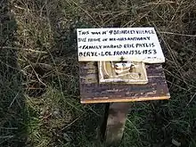
A military hospital was built on the heath during World War I. After the hospital was closed in the 1920s, local miners moved onto the site and dubbed it Brindley Village. It was finally demolished around 1951, and the occupants moved to Hednesford.[6] The parish electoral ward for the southern part of Brindley Heath parish is also named Brindley Village.
Brindley Heath railway station served Brindley Heath from 1939 to 1959 on the Chase Line
There was also a POW camp at Flaxley Green near Rugeley where the foundations can still be seen to this day.
See also
References
- "Census 2001". Archived from the original on 13 June 2011. Retrieved 15 January 2009.
- "Civil Parish 2015". Retrieved 5 December 2015.
- "BBC - WW2 People's War - A True War-Time Story". Archived from the original on 1 August 2012. Retrieved 4 February 2007.
- A Brief History Archived February 8, 2007, at the Wayback Machine
- Hednesford holiday and tourist travel guide from TourUK
- Staffordshire Past Track Archived May 24, 2011, at the Wayback Machine
- "Hybrid Bilberry". sbap.org.uk. Retrieved 4 July 2021.