Bouarfa, Morocco
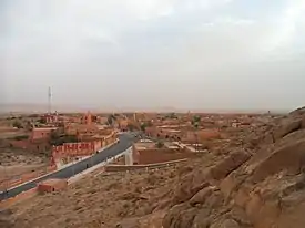
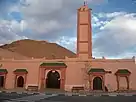
Bouarfa (Arabic: بوعرفة, Berber ⴱⵓⵄⴰⵔⴼⴰ) is a city in Oriental Region, northeastern Morocco and the capital of Figuig Province. According to the 2004 census, it had a population of 24,527.
Bouarfa<amazigh/> بوعرفة
ⴱⵓⵄⴰⵔⴼⴰ Bou 'rfa | |
|---|---|
City | |
   | |
 Bouarfa<amazigh/> بوعرفة ⴱⵓⵄⴰⵔⴼⴰ  Bouarfa<amazigh/> بوعرفة ⴱⵓⵄⴰⵔⴼⴰ | |
| Coordinates: 32°31′8″N 1°58′39″W | |
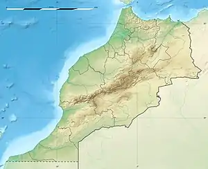
| Country | Morocco |
| Region | Oriental |
| Province | Figuig |
| Elevation | 1,174 m (3,854 ft) |
| Population (2014)[1] | |
| • Total | 28,846 |
Climate
| Climate data for Bouarfa (1991–2020) | |||||||||||||
|---|---|---|---|---|---|---|---|---|---|---|---|---|---|
| Month | Jan | Feb | Mar | Apr | May | Jun | Jul | Aug | Sep | Oct | Nov | Dec | Year |
| Record high °C (°F) | 24.1 (75.4) |
27.0 (80.6) |
30.9 (87.6) |
34.4 (93.9) |
38.6 (101.5) |
41.6 (106.9) |
43.4 (110.1) |
42.1 (107.8) |
39.2 (102.6) |
35.0 (95.0) |
28.5 (83.3) |
23.5 (74.3) |
43.4 (110.1) |
| Average high °C (°F) | 13.9 (57.0) |
16.0 (60.8) |
19.9 (67.8) |
23.8 (74.8) |
28.6 (83.5) |
34.1 (93.4) |
38.6 (101.5) |
37.3 (99.1) |
31.8 (89.2) |
25.4 (77.7) |
18.5 (65.3) |
14.5 (58.1) |
25.2 (77.4) |
| Daily mean °C (°F) | 7.9 (46.2) |
9.8 (49.6) |
13.6 (56.5) |
17.3 (63.1) |
21.8 (71.2) |
27.0 (80.6) |
31.3 (88.3) |
30.3 (86.5) |
25.1 (77.2) |
19.3 (66.7) |
12.8 (55.0) |
8.9 (48.0) |
18.8 (65.8) |
| Average low °C (°F) | 1.9 (35.4) |
3.6 (38.5) |
7.2 (45.0) |
10.7 (51.3) |
14.9 (58.8) |
19.8 (67.6) |
24.0 (75.2) |
23.2 (73.8) |
18.4 (65.1) |
13.2 (55.8) |
7.0 (44.6) |
3.3 (37.9) |
12.3 (54.1) |
| Record low °C (°F) | −8.0 (17.6) |
−7.1 (19.2) |
−2.8 (27.0) |
1.0 (33.8) |
3.9 (39.0) |
9.5 (49.1) |
15.4 (59.7) |
14.7 (58.5) |
7.4 (45.3) |
1.0 (33.8) |
−2.7 (27.1) |
−3.7 (25.3) |
−8.0 (17.6) |
| Average precipitation mm (inches) | 9.6 (0.38) |
10.4 (0.41) |
19.8 (0.78) |
13.5 (0.53) |
10.8 (0.43) |
7.2 (0.28) |
3.1 (0.12) |
11.4 (0.45) |
19.9 (0.78) |
24.9 (0.98) |
21.0 (0.83) |
11.8 (0.46) |
163.4 (6.43) |
| Average precipitation days (≥ 1.0 mm) | 2.4 | 1.8 | 2.8 | 2.3 | 1.7 | 1.2 | 0.8 | 2.6 | 3.4 | 2.6 | 2.7 | 2.0 | 26.3 |
| Source: NOAA[2] | |||||||||||||
References
- "POPULATION LÉGALE DES RÉGIONS, PROVINCES, PRÉFECTURES, MUNICIPALITÉS, ARRONDISSEMENTS ET COMMUNES DU ROYAUME D'APRÈS LES RÉSULTATS DU RGPH 2014" (in Arabic and French). High Commission for Planning, Morocco. 8 April 2015. Retrieved 29 September 2017.
- "Bouarfa Climate Normals 1991–2020". World Meteorological Organization Climatological Standard Normals (1991–2020). National Oceanic and Atmospheric Administration. Archived from the original on 9 September 2023. Retrieved 9 September 2023.

This article is issued from Wikipedia. The text is licensed under Creative Commons - Attribution - Sharealike. Additional terms may apply for the media files.