Bosteri
Bosteri is a village in the Issyk-Kul Region of Kyrgyzstan. It is part of the Issyk-Kul District.[1] Its population was 8,908 in 2021.[2] The town is entirely devoted to mass tourism. There are soviet-era hotels and sanitoria. To the west along highway A363 is Cholpon-Ata, and to the east Korumdu.
Bosteri
Бостери | |
|---|---|
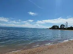 Beach "Tolkun" in Bosteri during sunny weather. June 2022. | |
 Coat of arms | |
 Bosteri | |
| Coordinates: 42°39′0″N 77°10′48″E | |
| Country | Kyrgyzstan |
| Region | Issyk-Kul Region |
| District | Issyk-Kul District |
| Established | ca. 1755 |
| Government | |
| • Ayil Okmotu | Uchkurkaev Zamir |
| Elevation | 1,601 m (5,253 ft) |
| Population (2021) | |
| • Total | 8,908 |
| Time zone | UTC+6 |
| Area code | 722316 |
Population
| Year | Pop. | ±% p.a. |
|---|---|---|
| 2009 | 7,415 | — |
| 2021 | 8,908 | +1.54% |
| Note: resident population; Sources:[2][3] | ||
Notable individuals
References
- "Classification system of territorial units of the Kyrgyz Republic" (in Kyrgyz). National Statistics Committee of the Kyrgyz Republic. May 2021. pp. 12–14.
- "Population of regions, districts, towns, urban-type settlements, rural communities and villages of Kyrgyz Republic" (XLS) (in Russian). National Statistics Committee of the Kyrgyz Republic. 2021. Archived from the original on 10 November 2021.
- "2009 population and housing census of the Kyrgyz Republic: Issyk-Kul Region" (PDF) (in Russian). National Statistics Committee of the Kyrgyz Republic. 2010. p. 221.
This article is issued from Wikipedia. The text is licensed under Creative Commons - Attribution - Sharealike. Additional terms may apply for the media files.