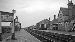
Blunham railway station
Blunham was a railway station on the Varsity Line which served the small village of the same name in Bedfordshire. Opened in 1862, the station was located in a rural area and saw little passenger traffic; it closed together with the line in 1968.
Blunham | |
|---|---|
 Blunham Station in 1961 | |
| General information | |
| Location | Blunham, Central Bedfordshire England |
| Grid reference | TL149505 |
| Platforms | 2 |
| Other information | |
| Status | Disused |
| History | |
| Original company | Bedford & Cambridge Railway |
| Pre-grouping | London and North Western Railway |
| Post-grouping | London, Midland and Scottish Railway London Midland Region of British Railways (1948-1958) Eastern Region of British Railways (1958-1968) |
| Key dates | |
| 7 April 1862 | Opened |
| 13 July 1964[1] | Closed to goods |
| 1 January 1968[2] | Closed to passengers |
History
Travelling from Oxford in the direction of Cambridge, Blunham was the first station on the Varsity Line which was built in the architectural style of the Bedford & Cambridge Railway, a style which included strong gables in yellow gault brick together with red brick dressings and string courses.[3] As with the other Bedford & Cambridge-built stations with the exception of Potton, the main station buildings were situated on the down side and a wooden shelter served for passengers on the up platform. The two platforms were low and steps were often needed to reach coaches, illuminated at night by the station's oil lamps.[4]
The station had a substantial goods shed which contained a 25cwt crane and sidings controlled by a 20-lever frame signal box.[5] A longer private siding led southwards to Beeson's Mill which produced linseed oil on the banks of the River Ivel.[6] The station like many others on the Bedford & Cambridge's line saw much traffic in vegetables - notably potatoes, leading to special trains being laid on to arrange for the collection of goods for carriage to Bletchley and onward transport to London.[7]
The station served a relatively rural community - there were 598 residents in 1901[8] - and this, coupled with its remote location to the south of Blunham village, left it susceptible to competition from the motor car.[9] The station eventually closed together with the Bedford & Cambridge-built section of the Varsity Line in 1968.
| Preceding station | Disused railways | Following station | ||
|---|---|---|---|---|
| Willington | British Railways Varsity Line |
Girtford Halt |
Present day
The main station building has been restored and converted into two semi-detached private residences respectively named "Stationmaster's Cottage" and "Station House".[10] The approach road to the station has been redeveloped as a new housing development called "Old Station Court" which continues westwards across the former railway alignment. To the east, the trackbed is intact including bridge no. 15 over the River Ivel which now forms part of National Cycle Route 51.
References
- Clinker, C.R. (October 1978). Clinker's Register of Closed Passenger Stations and Goods Depots in England, Scotland and Wales 1830-1977. Bristol: Avon-AngliA Publications & Services. p. 14. ISBN 0-905466-19-5.
- Butt, R.V.J. (1995). The Directory of Railway Stations, Patrick Stephens Ltd, Sparkford, ISBN 1-85260-508-1, p. 38.
- Simpson, Bill (1981). Oxford to Cambridge Railway (Vol. 2). Poole, Dorset: Oxford Publishing Co. p. 94. ISBN 0-86093-121-8.
- Davies, R.; Grant, M.D. (1984). Forgotten Railways: Chilterns and Cotswolds. Newton Abbot, Devon: David St John Thomas. p. 120. ISBN 0-946537-07-0.
- Mitchell, V.; Smith, K. (February 2007). Bletchley to Cambridge featuring Bedford St. Johns. Midhurst, West Sussex: Middleton Press. p. plates 74 and 76. ISBN 978-1-904474-94-4.
- Oppitz, Leslie (2000). Lost Railways of the Chilterns (Lost Railways Series). Newbury, Berkshire: Countryside Books. p. 144. ISBN 978-1-85306-643-6.
- Davies, R. and Grant, M.D., p. 119.
- Mitchell, V. and Smith, K., plate XIX.
- Simpson, Bill (2000). The Oxford to Cambridge Railway: Forty Years On 1960-2000. Witney, Oxford: Lamplight Publications. p. 15. ISBN 1-899246-05-3.
- Blunham station. Archived 4 July 2008 at the Wayback Machine
External links
 Media related to Blunham railway station at Wikimedia Commons
- "Disused Stations". Subterranea Britannica.
- Blunham station on navigable 1946 O. S. map